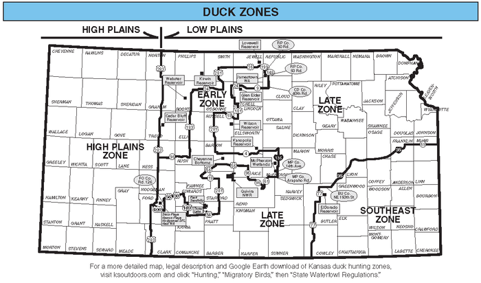
Kansas Duck Hunting Zone Descriptions

South on federal highway US-283 to the Kansas-Oklahoma state line; west along the Kansas–Oklahoma state line to its junction with the Kansas-Colorado state line; north along the Kansas-Colorado state line to its junction with the Kansas-Nebraska state line; east along the Kansas-Nebraska state line to its junction with federal highway US-283.
East on state highway K-96 to its junction with federal highway US-183 in Rush Center, Kansas; north on federal highway US-183 to its junction with federal highway US-24 in Stockton, Kansas; east on federal highway US-24 to its junction with federal highway US-281 in Osborne, Kansas; north on federal highway US-281 to its junction with federal highway US-36 in Smith Center, Kansas; east on federal highway US-36 to its junction with state highway K-199 in Courtland, Kansas; south on state highway K-199 to its junction with Republic County 30th Road (Main Street) at Courtland City, Kansas; south on Republic County 30th Road (Main Street in Courtland City) to its junction with state highway K-148; east on state highway K-148 to its junction with Republic County Road 5; south on Republic County Road 5 to its junction with Cloud County North 40th Road; south on Cloud County North 40th Road to its junction with state highway K-9; west on state highway K-9 to its junction with federal highway US-24 in Beloit, Kansas; west on federal highway US-24 to its junction with state highway K-181 in Downs, Kansas; south on state highway K-181 (Morgan Avenue in Downs city limits) to its junction with state highway K-18; west on state highway K-18 to its junction with federal highway US-281 in Luray, Kansas; south on federal highway US-281 to its junction with state highway K-4 (East 9th St) in Hoisington, Kansas; east on state highway K-4 to its junction with interstate highway I-135 (US-81); south on interstate highway I–135 (US-81) to its junction with state highway K-61; southwest on state highway K-61 to its junction with McPherson County 14th Avenue; south on McPherson County 14th Avenue to its junction with McPherson County Arapaho Rd; west on McPherson County Arapaho Rd to its junction with state highway K-61; southwest on state highway K-61 to its junction with state highway K-96; northwest on state highway KS-14/K-96 to its junction with federal highway US-56 in Lyons, Kansas; west to Great Bend, Kansas then southwest on federal highway US-56 (East 14th Street) to its junction with state highway K-19 Spur (Broadway Street) in Larned, Kansas; south on state highway K-19 Spur (Broadway Street) to K-19 (NW 140th Street); east on state highway K-19 (NW 140th Street) to its junction with federal highway US-281; south on federal highway US-281 to its junction with federal highway US-54 in Pratt, Kansas; west on federal highway US-54 to its junction with federal highway US-183; north on federal highway US-183 to its junction with federal highway US-56 in Kinsley, Kansas; southwest on federal highway US-56 to its junction with North Main Street in Spearville, Kansas; south on North Main Street to Davis Street in Spearville, Kansas; east on Davis Street to Ford County Road 126 (South Stafford Street) in Spearville, Kansas; south on Ford County Road 126 (Spearville Road) to Garnett Road; east on Garnett Road to Ford County Road 126; south on Ford County Road 126 to Ford Spearville Road; west on Ford Spearville Road to its junction with federal highway US-400; northwest on federal highway US-400 to its junction with federal highway US-283 in Dodge City, Kansas; north on 113th Road to federal highway US-56 (E Wyatt Earp Boulevard) in Dodge City, Kansas; northeast on federal highway US-283/US-56 to its junction with US-283/US-50/US-56; east on federal highway US-283/US-50/US-56 to its junction with federal highway US-283; north on federal highway US-283 to its junction with federal highway US-96 in Ness City, Kansas.
Forth on federal highway US-283 to the Kansas-Nebraska state line; east along the Kansas-Nebraska state line to its junction with the Kansas-Missouri state line; southeast along the Kansas-Missouri state line to its junction with state highway K-68; west on state highway K-68 to its junction with interstate highway I-35 in Ottawa, Kansas; southwest on interstate highway I-35 to its junction with Butler County NE 150th Street; west on Butler County NE 150th Street to its junction with federal highway US-77; south on federal highway US-77 to its junction with the Kansas-Oklahoma state line; west along the Kansas-Oklahoma state line to its junction with federal highway US-283; north on federal highway US-283 to its junction with federal highway US-400 in Dodge City, Kansas; southeast on federal highway US-400 to its junction with Ford Spearville Road; east on Ford Spearville Road to Ford County Road 126; north on Ford County Road 126 to Garnett Road; west on Garnett Road to Ford County Road 126; north on Ford County Road 126 (Spearville Road and then South Stafford Street in Spearville, Kansas) to Davis Street in Spearville, Kansas; west on Davis Street to North Main Street in Spearville, Kansas; north on North Main Street to its junction with federal highway US-56 in Spearville, Kansas; east on federal highway US-56 to its junction with federal highway US-183 in Kinsley, Kansas; south on federal highway US-183 to its junction with federal highway US-54; east on federal highway US-54 to its junction with federal highway US-281 in Pratt, Kansas; north on federal highway US-281 to its junction with state highway K-19; west on state highway K-19 to its junction with K-19 Spur (Broadway Street); north on state highway K-19 Spur (Broadway Street) to its junction with federal highway US-56 (East 14th Street) in Larned, Kansas; northeast to Great Bend, Kansas and then east on federal highway US-56 to its junction with state highway K-96/K-14 in Lyons, Kansas; southeast on state highway K-96/K-14 to its junction with state highway K-61; northeast on state highway K-61 to its junction with McPherson County Arapaho Road; east on McPherson County Arapaho Road to its junction with McPherson County 14th Avenue; north on McPherson County 14th Avenue to its junction with state highway K-61; east on state highway K-61 to its junction with interstate highway I-135 (US-81); north on interstate highway I-135 (US-81) to its junction with state highway K-4; west on state highway K-4 to its junction with federal highway US-281 (West 9th St) in Hoisington, Kansas; north on federal highway US-281 to its junction with state highway K-18 in Luray, Kansas; east on state highway K-18 in Luray, Kansas to its junction with federal highway US-181; north on federal highway K-181 to its junction with federal highway US-24 in Downs, Kansas; east on federal highway US-24 to its junction with state highway K-9 in Beloit, Kansas; east on state highway K-9 to its junction with Cloud County 40th Road; north on Cloud County North 40th Road to its junction with Republic County Road 5; north on Republic County Road 5 to its junction with state highway K-148; west on state highway K-148 to its junction with Republic County 30th Road; north on Republic County 30th Road (Main Street in Courtland City) to its junction with state highway K-199 in Courtland, Kansas; north on state highway K-199 to its junction with federal highway US-36; west on federal highway US-36 to its junction with federal highway US-281 in Smith Center, Kansas; south on federal highway US-281 to its junction with federal highway US-24 in Osborne, Kansas; west on federal highway US-24 to its junction with federal highway US-183 in Stockton, Kansas; south on federal highway US-183 to its junction with federal highway US-96 in Rush Center, Kansas; west on federal highway US-96 to its junction with federal highway US-283 in Ness City, Kansas.
West on state highway K-68 to its junction with interstate highway I-35 in Ottawa, Kansas; southwest on interstate highway I-35 to its junction with Butler County NE 150th Street; west on Butler County NE 150th Street to its junction with federal highway US-77; south on federal highway US-77 to its junction with the Kansas-Oklahoma state line; east along the Kansas–Oklahoma state line to its junction with the Kansas-Missouri state line; north along the Kansas-Missouri state line to its junction with state highway K-68.


