Hunting Atlas
Public hunting access to the Walk-In Hunting Access (WIHA) properties is limited to the specified access period for the property.
Access dates for fall WIHA properties begin either September 1 or November 1, and end January 31, March 31, or May 31. Please check the specific access date for each property in the Hunting Atlas or on posted WIHA signs at the property.
Accessing the WIHA properties prior to or after the open access period is prohibited.
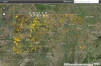
Click the link above for a searchable web map showing the Fall 2025 & Spring 2026 WIHA properties. Click on individual tracts to display walk-in property information. Zoom to areas by city or county name with the search box and choose from various base map options.
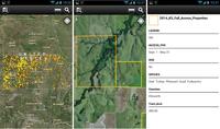
Use the free ArcGIS Field Maps App to bring the WIHA tracts to your mobile device (data signal required). On your mobile device go to your application store (App Store or Google Play) and search for "ArcGIS Field Maps" to download application. Once the app is installed on your device, search the Maps for "KDWP" and select the "KDWP: 2025-2026 WIHA" map to view the current WIHA properties.
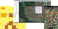
Files and instructions for various location format options. Includes Garmin GPS, Google Earth/GE Mobile, and Point/Lat-Long .txt and .csv files.
Printed Hunting Atlases can be picked up at any KDWP office and everywhere licenses are sold.


