Perry Wildlife Area
Much of Perry Wildlife Area lies within the Perry Reservoir flood pool, thus flooding is not uncommon. The Delaware River bisects the area from north to south with several small creeks feeding it. The area has a diversity of habits with interspersion of Oak-Hickory woodlands, warm and cool season grasslands, man-made wetlands, and several acres of cropland.
In the mid 1970's, 11 marsh complexes were built. Two additional marshes were developed after 2000. These marshes provide about 1,000 acres of wetland habitats. The Kyle Marsh, West River Marsh, Reichart Marsh and Northwest Marsh can be pumped from the Delaware River to provide habitat for migratory birds during dry years. All other wetlands depend on natural run off, thus water levels may vary from year to year.
Moist soils management is conducted on all marshes which uses water level fluctuations to manage for desirable wetland vegetation beneficial to migratory birds. Periodically, some marshes will be drained in order to conduct dike repairs and control invading woody vegetation and cattails. Management of upland habitats over the years has consisted of converting croplands and cool season grasses to native warm season grasses and forbs, planting of shrub plots, selective cutting of invading woody vegetation, and prescribed burning to stimulate native warm season grasses and forbs.
White-tailed deer and wild turkey are plentiful on the area. Waterfowl numbers vary depending on available habitat, but the area has supported large numbers during both the fall and spring migrations. Mourning dove numbers vary yearly depending on nesting conditions. Ring-necked pheasant can be found on the area with good numbers on the area. Bobwhite quail populations are good on the area, but a good dog is needed due to the dense vegetation. Squirrel and cottontail rabbit numbers are generally healthy and provide some of the most under utilized hunting opportunities on the area.
Non-game species are very plentiful on the area and provide some of the best wildlife viewing opportunities. A wide array of mammals, birds, reptiles, and amphibians can be found on the area.
Fishing for catfish, white bass, and crappie in the Delaware River are also popular activities. Trapping which is allowed on the area, can be a very successful venture due to the wide array of furbearer habitats.
Special Features
Handicapped access area. Written permission required from manager for operating vehicle off road in designated area.
Mentor/Youth access area designated for youth 17 years and younger accompanied by no more than one adult per youth.
Two boat ramps are located on the Delaware River South of Valley Falls. West River Boat Ramp is located at 150th Street on the West side of the Delaware River and Walker Bridge Boat Ramp is located on Hamilton Road East of the Delaware River.
Perry W.A. is heavily used due to its proximity to major metropolitan areas. Opening days and weekends of all seasons are busiest.
Manager: Andrew Page
Phone: 785-945-6615
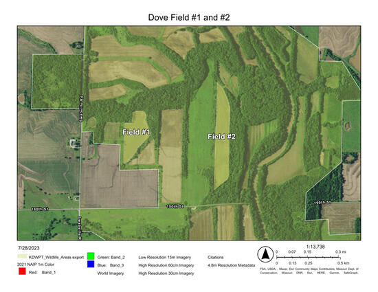
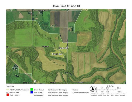
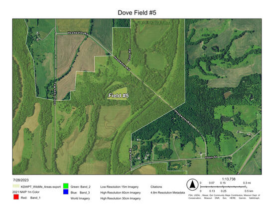
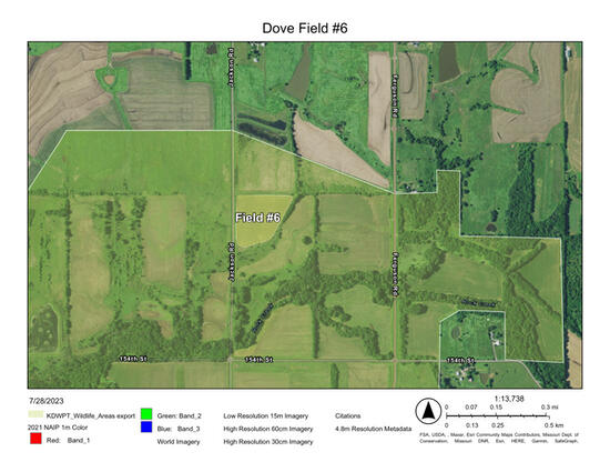
Eight managed Dove fields are located on the Perry Wildlife Area totaling about 85 acres. ALL DOVE FIELDS ON PERRY WILDLIFE AREA ARE NON-TOXIC SHOT ONLY AND REQUIRE USE OF THE ELECTRONIC DAILY HUNT PERMIT SYSTEM. All fields are sunflowers with the centers of the fields mowed out for hunters to sit around the perimeter of each field.
Maintain safe shooting distances between hunting parties and always know what lies beyond your target. It is highly recommended that hunters where safety/shooting glasses within the dove fields to prevent potential injury due to falling pellets.
Detailed information will be posted on the Perry Wildlife Area web page.
Perry Wildlife Area is included in the electronic daily hunt permit system. This system, which will streamline data gathering for management purposes and be convenient for hunters, has taken the place of the old paper dove survey card system. Hunters can register at any time by going to ksoutdoors.gov/checkin to register and check-in for hunting. After you are done hunting, you will “check-out” and record any harvest you may have from the hunt. Electronic daily hunt check-in is mandatory for all hunters pursuing any type of game on the Perry Wildlife Area
For additional information go to: ksoutdoors.gov/checkin or call Public Lands Section at 620-672-5911.
Field #1:Non-Toxic shot only. Refuge field closed to public hunting/access, will open Saturday, September 6th. This field is located North of 190th Rd. East of Swabville and totals 13.1 acres. This is the West field of the two sunflower fields North of 190th this season.
Field #2: Non-Toxic shot only. This field is located North of 190th Rd. East of Swabville and totals 19.4 acres. This is the East field of the two sunflower fields North of 190th this season.
Field #3: Non-Toxic shot only. This field is located immediately West of Finney Road just North of the intersection of 170th/Finney Road and totals 8.5 acres
Field #4: Non-Toxic shot only. This field is located immediately South of 170th Road just West of the intersection of 170th/Finney Road and totals 9.2 acres.
Field #5: Non-Toxic shot only. This field is reserved for a special youth hunt being held on Monday, September 1st . It is closed to all activities/access until Tuesday September 2nd , then it opens to all public hunting. This field is located just south of Headwater Road and is accessed by walking past the gate on the South side of Headwater along the old railroad access. 5.7 acres.
Field #6: Non-Toxic shot only. This field is the youth/disabled field which is 13.5 acres and located just East of Jackson Road North of the intersection of 154th/Jackson Road in the Youth/Mentor/Handicapped area. Each adult must be accompanied by an actively hunting youth to be hunting this field.
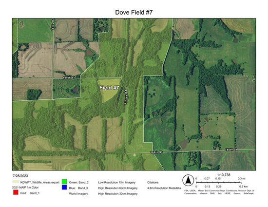
Field #7: Non-Toxic Shot Only. This field is located near the intersection of Finney Road and 190th immediately South of 190th Road and totals 9.6 acres.
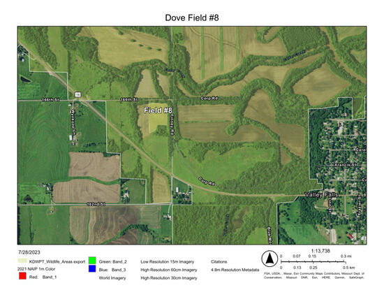
Field #8: Non-Toxic shot only. This field is reserved for a special veteran’s hunt being held on Monday, September 1st AND Wednesday September 3rd. It is closed to all activities/access until Thursday, September 4th when it opens to all public access. This field is located just South of 166th and West of Finney Rd and totals 6 acres.
- Camping, horse-back riding, ATV riding, and target shooting are prohibited activities. See Public Lands Regulations Summary for additional restrictions.
- All vehicles must stay on maintained roads and parking areas. Off-road driving is prohibited.
- Please do not park in front of or block gates and field accesses.
- Refuge areas are closed to all activities from October 1 through January 15.
- Gas Powered boats are prohibited from use on all marshes except for the east and west pools of the Kyle marsh complex, Sunset Ridge, and Rucker Marsh.
Here is a complete list of Public Land Regulations or you can download the regulation summary.
The Kansas Department of Wildlife & Parks has leased 10,500 acres of land at the north end of the Perry Reservoir Project from the U.S.Corps of Engineers since 1970. The area is operated and managed by the Department for wildlife management and public hunting opportunities.
- Type of Facility: Boat Ramp
- Location of Facility: N39 19.114 W095 26.490
- Click for more information
- Type of Facility: marsh
- Location of Facility: N39 21.292 W095 29.317
- Click for more information
- Type of Facility: marsh
- Location of Facility: N39 22.260 W095 28.917
- Click for more information
- Type of Facility: marsh
- Location of Facility: N39 22.783 W095 30.094
- Click for more information
- Type of Facility: marsh
- Location of Facility: N39 21.302 W095 28.265
- Click for more information
- Type of Facility: marsh
- Location of Facility: N39 22.759 W095 28.759
- Click for more information
- Type of Facility: marsh
- Location of Facility: N39 17.741 W095 27.082
- Click for more information
- Type of Facility: marsh
- Location of Facility: N39 18.692 W095 26.650
- Click for more information
- Type of Facility: marsh
- Location of Facility: N39 19.127 W095 25.637
- Click for more information
- Type of Facility: marsh
- Location of Facility: N39 17.860 W095 25.291
- Click for more information
- Type of Facility: marsh
- Location of Facility: N39 19.376 W095 26.372
- Click for more information
- Type of Facility: marsh
- Location of Facility: N39 19.563 W095 26.057
- Click for more information
| Waterfowl Updates | A waterfowl survey was conducted on 12/29/25 and wetlands are mostly froze over but the Delaware River is open. Large concentrations of divers on big open water around Lake Perry. We will likely be dealing with some ice coverage for a while with the weather forecasts.
ATTENTION WATERFOWL HUNTERS - LEGAL SHOOTING LIGHT IS FROM 3O MINUTES BEFORE SUNRISE TO SUNSET. *DON'T FORGET TO CHECK-IN / CHECK-OUT HERE, https://ksoutdoors.com/checkin using your licensing login credentials.
|
| Lake level | 2.36 Feet Above Conservation Pool |
| Habitat conditions | Mild flooding in the spring, followed by a dry spell for the bulk of the middle of the summer allowed for a great amount of pool work and supplemental food such as Japanese Millet and Sorghum strips being planted in multiple wetlands. Rains in the later half of the summer encouraged good native moist soil vegetation and helped with the vegetation planted as well.
|
| Comments | Habitat Condition Rating (HCR): 1-10; 1-Poor habitat, 5-quality habitat, 10-Exceptional habitat Reminder: Gas powered boats are only allowed on the River, Lake, Sunset Ridge, Kyle East and West and Rucker wetland pools. Electric powered boats are allowed in all marsh pools. Kyle: Pumping is complete and the East and West Units are 100% full. Utilized a drone to spray most of the invasive River Bulrush in the East unit of Kyle, but no mechanical manipulation was done due to wet conditions throughout the summer. HCR-5 West River: A significant amount of the upper and lower unit of West River as disked and planted to Japanese Millet with some sorghum strips throughout. In the lower unit, we utilized a drone to spray most of the invasive River Bulrush on the West side of the drainage ditch which did promote some growth of native moist soil vegetation underneath as the rush died down. Some pumping has been done and will continue throughout season with a good amount of huntable water in the upper unit and the middle of the lower unit and some water starting to show down at the lower levee. HCR-8 Upper Ferguson: This wetland grew mostly native smartweed and has little water currently. The water control structure is currently removed and a new one is expected to be here to install in the next couple months or so. The refuge is closed Oct 1st thru Jan 15th to ALL Activity HCR-6. Lassiter: Water was held all year in both the East and West Unit of Lassiter which led to a large amount of perennial vegetation growth making the wetland fairly thick in the early season. Little open water is available until some of the vegetation starts to die down this fall/winter. Full pool. HCR-5 Northwest: This unit was mostly planted to corn and pumping is complete. 100% full. The area not planted to corn was mostly disked and planted to Japanese Millet with sorghum strips in it as well. HCR-7 Headquarters: Corn was planted in this marsh and boards are in the structure awaiting rainfall to fill. No water currently. HCR-7 Mitigation: Unit was drawn down this year to improve the access trail and mow down some of the thick perennial vegetation and trees that started to develop. No water collected yet. HCR-7 Hayward: Unit was drawn down and large portions of it disked and planted to Japanese Millet with some native moist soil vegetation response as well. No water collected yet. HCR-8 Reichart: Water was held in the NW Unit of Reichart and is near full now with marginal wetland vegetation because of holding water all summer. The rest of Reichart has been pumped and has Corn on the NE end and native moist soil vegetation throughout the rest of the marsh. Full pool. HCR-8. Zebra Mussels have been confirmed in the lake. Be sure to dry boats and equipment before moving to other waters. Please remember to fill out the permit with accurate information. THIS INFORMATION IS VERY IMPORTANT TO THE CURRENT AND FUTURE MANAGEMENT OF THE AREA. FILL OUT ONLY YOUR INDIVIDUAL HARVEST EFFORTS, i.e., NOT A GROUP HARVEST TOTAL. |


