


Lovewell Reservoir
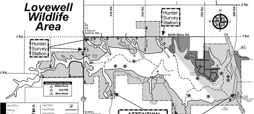
Map of Lovewell Reservoir


Click here for a Google Earth map of Lovewell
Click here to download a map of Lovewell
Lovewell Wildlife Area has 2,215 acres of public hunting area available around the reservoir. Lovewell Dam impounds approximately 3,000 surface acres of water and is situated on White Rock Creek. Lovewell is an irrigation reservoir with seasonally changing water levels. Expect lower water levels in the late summer through winter months but the reservoir is refilled annually by diverting water from the Republican River at Guide Rock, Nebraska into a canal that empties into the northeast corner of the reservoir. This area is small and receives heavy hunting and fishing pressure.
Species managed for include deer, turkey, waterfowl and upland game like pheasant, quail, rabbit and squirrel. Management will focus on increasing the quality of the experience for visitors by managing wildlife and habitats with an ecological based approach as the primary goal. The limited public lands in Kansas require intensive wildlife management and some special restrictions will be used to provide quality hunting and fishing areas.
INLET CANAL CLOSED TO FISHING SEPTEMBER 15 THROUGH APRIL 15.
NEW REFUGE REGULATIONS:THE LAND REFUGE CLOSED TO HUNTING YEAR ROUND. CLOSED TO OTHER ACTIVITIES YEAR-ROUND. WATER REFUGE IN EFFECT NOVEMBER 1 THROUGH APRIL 15 on the NORTHEAST half of the reservoir and Wildlife Area from 1/8th mile west of the south end of the dam and following a buoy line northwest to the western boundary of the Cabin Area. No hunting from the park shoreline.
You can follow the reservoir water levels by going to this website, http://www.usbr.gov/gp-bin/arcweb_lvks.pl
Lovewell FREE and MANDATORY HUNTER CHECK-IN
ALL Hunters are REQUIRED to register your hunting activity electronically here, https://ksoutdoors.com/checkin using your licensing login credentials. Please register prior to arriving on the property as mobile phone and internet service is sketchy. FREE wi-fi is available in front of the Lovewell Office.
Prior to the day’s hunt check-in choosing the property and the species you are primarily hunting. Have your Vehicle Information handy as this is one of the check-in requirements When the hunt is finished, log back in and record harvest and location you hunted on the property.Hunter participation and cooperation is critical to the success of this study.
Persons wanting additional information or questions should contact the Hays Regional Office at 785-628-8614 or the specific area they plan to hunt. Lovewell (785) 753-4971. Jamestown (785) 439-6243.
Special Hunts and Refuge Areas are in effect September 1 - April 1.
Camping is only allowed in designated areas as a companion activity to hunting and fishing.
Horses are restricted to maintained roads and are not allowed off roads.
ATV/UTV's are prohibited anywhere on the area.
A permit to access a designated ADA vehicle access area is available from the manager to persons meeting the requirements.
Here is a complete list of Public Land Regulations or you can download the regulation summary.
The 4,625 acre Lovewell Wildlife Area was made available to the Kansas Forestry Fish and Game Commission under terms of a lease agreement with the Department of Interior in 1959 after the completion in 1957 of Lovewell Reservoir, a 3,000 acre flood control and irrigation reservoir. In 1972, 200 acres were purchased by the Kansas Fish and Game Commission and is owned by the state of Kansas. Lands previously managed by the Kansas Park Authority that were transferred to KFG now bring the total area leased from the Bureau of Reclamation under wildlife management to 5,215 acres.
- Type of Facility: Parking
- Location of Facility: 39.883701 -98.028359
- Click for more information
- Type of Facility: Boat Ramp
- This facility is ADA accessible
- Location of Facility: 39.894353 -98.074166
- Click for more information
- Type of Facility: Information Center
- Location of Facility: 39.887948 -98.101985
- Click for more information
- Type of Facility: Boat Ramp
- This facility is ADA accessible
- Location of Facility: 39.905462 -98.115361
- Click for more information
- Type of Facility: Parking
- Location of Facility: 39.909385 -98.105366
- Click for more information
- Type of Facility: Parking
- Location of Facility: 39.906907 -98.088333
- Click for more information
- Type of Facility: Parking
- Location of Facility: 39.907469 -98.080463
- Click for more information
- Type of Facility: Parking
- Location of Facility: 39.911082 -98.070839
- Click for more information
- Type of Facility: Fishing Area
- This facility is ADA accessible
- Location of Facility: 39.906000 -98.022811
- Click for more information
| Waterfowl numbers | The numbers of light geese using the reservoir as a day roost is greatly reduced, less than 1,000. Numbers vary greatly day to day as there is no snow line north of us so geese are pushing northward for spring migration to the breeding grounds. |
| Mallard Migration Ranking | |
| Water level | Lovewell Reservoir is holding at 1579.6 or 3.0 feet below Conservation Pool,( 73.7% full).The elevation has been near this elevation for the past 90 days. Inflows from the Guide Rock Diversion Canal from the Republican River is being used to refill the reserervoir but no inflow at this time. Irrigation season ended on 9/13. |
| Hunting condition | NO ICE. 100% open water. Hunting conditions during this late winter/early s[ring are heavily dependent on local snow cover and a snow line north of us in Nebraska to halt the migration. There os no snow line. Current water levels have created a mudflat ring around the entire reservoir. Little concealing vegetation is close to the waters edge. No Japanese millet was planted this year due to higher than normal water elevations during the planting season resulting in no mudflats available to seed LOVEWELL RESERVOIR HAS NO WATCHES OR WARNINGS FOR HARMFUL ALGAE BLOOMS. USERS SHOULD STILL BE ON THE LOOKOUT FOR POCKETS OF HARMFUL ALGAE BLOOMS. ALL BOAT RAMPS ARE OPEN, CEDAR POINT IN LOVEWELL STATE PARK, THE MARINA IN THE PARK AND PAWNEE POINT AND OAK HILL ON THE WILDLIFE AREA. WHITE ROCK CREEK AREA IS OUT OF WATER AND CLOSED TO VEHICLES AT THIS ELEVATION. OAK HILL IS AT THE BOTTOM OF THE CONCRETE RAMP AT THIS ELEVATION. USE CAUTION FOR LARGER BOATS AND TRAILERS. ALL BOATS ARE REQUIRED TO USE NAVIGATION LIGHTS WHILE OPERATING BETWEEN THE HOURS OF SUNSET AND SUNRISE. PFD'S MUST NOT BE STOWED IN ANY COMPARTMENT WHILE THE BOAT IS UNDER POWER. KEEP THEM OUT OR BETTER YET ...ON! NON-MOTORIZED BOAT NEED SOME FLASHLIGHT OR LANTERN. |
| Expected hunting success | POOR ON THE WILDLIFE AREA DUE TO THE WARM CONDITIONS. WATERFOWL ARE VERY REFUGE ORIENTED DUE TO PAST AND PRESENT HUNTER AND ANGLER PRESSURE. POOR SUCCESS ON PRIVATE LAND OBTAIN PERMISSION FROM ALL PRIVATE LANDOWNERS BEFORE HUNTING ON ANY OF THEIR PROPERTY |
| Comments | REFUGE REGULATIONS: The land refuge closed to hunting and other activities year-round. Water refuge in effect November 1 through April 15 on the NORTHEAST half of the reservoir and Wildlife Area from 1/8th mile west of the south end of the dam and following a buoy line northwest to the western boundary of the Cabin Area of the State Park. This area open to fishing south and east of the buoy line from the north end of the dam to the Lovewell State Park Twin Coves trailer area. Inlet canal closed to fishing September 15 through April 15. BOAT RAMPS: SEE HUNTING CONDITION FOR BOAT RAMP STATUS. The State Park boat ramps require a Kansas State Park Permit. The Wildlife Area Boat Ramps are Pawnee Point, Oak Hill and White Rock Creek do not require a permit. CAMPING CABINS are available in Lovewell State Park. Make reservations HERE HUNTERS ARE ENCOURAGED TO :
FOLLOWING SAFE AND ETHICAL PRACTICES WILL ENSURE THAT EVERYONE HUNTING PUBLIC LANDS ENJOYS A HIGH-QUALITY EXPERIENCE. Hunters can check-in / check-out here, https://license.gooutdoorskansas.com using your licensing login credentials. Contact the office for other arrangements. We thank you for your patience. Please introduce youth and novice hunters to the outdoors. Pass it on! |