


Ducks

Most of the 27 species of ducks which frequent Kansas are produced in states and the Canadian provinces to the north. Although 14 species of ducks are known to have nested in Kansas, the major portion of the resident breeding population, estimated at about 20,000 pairs, is composed of wood ducks, blue-winged teal and mallards.
From 1984 through 2003 the total number of ducks reported during the 14 surveys conducted annually (two per month, September through March) on major waterfowl areas in Kansas varied from a high of 3,959,000 in 1998 to a low of 1,194,000 in 1991, and averaged approximately 2,081,000 annually. Generally speaking, duck numbers and harvest declined from levels experienced during the 1970’s, when an all time high of 10,015,000 ducks were reported during waterfowl surveys in 1972, and the average number observed each year (1970-79) was 5,820,000. This decline in Kansas duck numbers is largely due to loss of breeding habitat in Canada and states north of Kansas, aging of our reservoirs, and changing agricultural practices in our state.

The five most common ducks observed during the 14 annual surveys in Kansas include the mallard, northern pintail, green-winged teal, gadwall and blue-winged teal. Kansas is about half way down the Central Flyway’s eastern tier of states, an area crossed by some of the major migration routes of ducks. Of the five most common ducks, blue-winged teal are the first to arrive, peaking in September and early October. The next major influx of migrants occurs in late October and early November. Northern pintail begin a major buildup in late October, with green-winged teal and gadwall arriving and peaking during the first half of November. Mallards are the last of the top five to arrive, peaking in late December. The mallard is king in our state, with numbers observed commonly reaching 300,000 during the second half of December.
Although the migration chronology of Kansas ducks varies considerably from year to year, depending on weather, there is usually a gradual increase in duck numbers beginning in late August and peaking during December or early January. While data summarized on a statewide basis may show a gradual buildup of ducks, the numbers observed on a particular wetland may have migration characteristics quite different from the “state average”. A common misconception is that there is a gradual movement of ducks, north to south, during the fall and early winter periods. However, a shallow marsh near the Oklahoma border may have peak numbers in late October while a reservoir near the Nebraska border may not see maximum numbers until late December. Within Kansas, the type of habitat has a greater influence on the timing and species composition of the duck migration than does the location.
Over the long term, the fall and winter populations of ducks in Kansas should roughly correlate with the breeding population index for these species. However, numbers observed are influenced by habitat conditions in our state. Even in years of high flyway populations, poor habitat conditions in Kansas will lower fall populations and harvest in Kansas. Conversely, in years of low flyway populations, good habitat conditions in Kansas will raise Kansas fall populations and harvest.

Mallards - photo Mike Blair
During the past six years (1999-2004), Kansas duck hunters averaged approximately 119,000 duck hunting days, and harvested about 228,000 ducks annually. The highest Kansas duck harvest reported occurred in 1971, when an estimated 430,000 ducks were taken. In recent years, mallards have comprised about 50 percent of the total harvest, followed by gadwall at about 14 percent, and green-winged teal at 12 percent.
The future of ducks, unlike geese, is troubling. The long term degradation and loss of wetlands and native prairie on their breeding grounds is a serious problem that is difficult to address. The combination of the agricultural Conservation Reserve Program and record breaking rainfall allowed breeding numbers to rebound during the 1990’s to levels similar to those observed during 1970’s. However, discontinuance of the Conservation Reserve Program, or a return to normal rainfall levels on the breeding grounds, will have severe negative impacts on duck production and fall flights. Federal and state agencies, along with a number of private organizations are working to maintain quality breeding habitat, but the task is difficult and far from being accomplished.
For weekly updates on waterfowl numbers on Wildlife Areas during the fall and winter period go to the regional waterfowl reports.
Waterfowl Hunting regulations are set annually. Click here to view the latest Kansas Hunting & Furharvesting Regulations Summary.
Youth Waterfowl Seasons:In each of the duck zones, two days are set aside for youth waterfowl hunting (ducks and dark geese). Hunters 15 and younger may hunt under the supervision of an adult 18 or older. The adult may NOT hunt.
Daily Bag Limit: Any combination of six ducks and/or mergansers which may include no more than five mallards (only two of which may be hens), three wood ducks, two redheads, two canvasbacks, one scaup and one pintail.
Possession Limit: Three times the daily bag limit.
Legal Methods of Taking Waterfowl: Bow and arrow, falconry, or shotgun no larger than 10-guage. Shotguns shall not be able to hold more than three shells.
Illegal Methods of Taking Waterfowl:
No person shall take migratory game birds:
- 1) With a shotgun capable of holding more than three (3) shells, in the magazine and chamber combined.
- 2) With a trap, snare, fishhook, net, rifle, pistol, shotgun slug, shotgun larger than 10 gauge, poison, drug, or explosive.
- 3) With the use or aid of electronically amplified or recorded bird calls, or imitations of bird calls or sounds.
- 4) From a sink box (a low floating device, having a depression affording the hunter means of concealment beneath the surface of the water).
- 5) From or by means of any motor boat or sail boat unless the motor has been completely shut off and/or the sail furled, and its progress from there has ceased.
- 6) By the use or aid of live decoys. All tame, captive ducks and geese must be removed 10 days before hunting.
- 7) By driving, rallying, or chasing birds with any motorized conveyance or any sail boat to put them in range of the hunters.
Wanton Waste: By regulation, hunters must attempt to find any game crippled or killed. Retrieved animals must be kept until: 1) cleaned, 2) eaten, 3) taken home, 4) taken to a taxidermist or processor, or 5) given to another person.
Possession of Live Birds: Wounded waterfowl reduced to possession shall be immediately killed and included in the daily bag.
Transporting Harvested Waterfowl: One fully-feathered wing and /or head must remain attached to waterfowl when transported.
Shipment: No person shall ship migratory game birds unless the package is marked on the outside with: 1) the name and address of the person sending the birds, 2) the name and address of the person to whom the birds are being sent, and 3) the number of birds, by species, contained in the package.
Giving or Receiving Waterfowl: No person may receive, possess, or give to another, any freshly killed migratory game birds as a gift, except at the personal abodes of the donor or donee, unless such birds have a tag attached, signed by the hunter who took the birds, stating the hunter’s address, the total number and species of birds, and the date such birds were taken.
Tagging Requirements: No person shall put or leave any migratory game birds at any place (other than at his personal abode), or in the custody of another person for picking, cleaning, processing, shipping, transportation, or storage (including temporary storage), or for the purpose of having taxidermy services performed, unless such birds have a tag attached, signed by the hunter, stating his address, the total number and species of birds, and the date such birds were killed. Migratory game birds being transported in any vehicle as the personal baggage of the possessor are not considered as being in storage or temporary storage.
Electronic or Mechanically Operated Decoys:The use of electronic or mechanically operated decoys that do not produce bird sounds is legal.
Waterfowl Baiting Regulations: Baiting regulations differ between doves and waterfowl, and are among the most troublesome for hunters to understand. For detailed information on waterfowl baiting go to http://www.le.fws.gov/HuntFish/waterfowl_baiting.htm
Some general baiting rules that waterfowl hunters should remember:
- They may not place, expose, deposit, distribute or scatter salt, grain or other feed that could lure waterfowl to, on or over the area where they are hunting.
- They may not hunt a baited area until 10 days after all bait or feed has been completely removed.
- Hunters are responsible for ensuring that the area they plan on hunting has not been baited before they start hunting.
- Hunters may hunt all migratory game birds over natural vegetation that has been mowed or manipulated in other ways, or where seeds or grains have been scattered solely as a result of a normal agricultural planting or normal soil stabilization practice.
- Hunters may use natural vegetation to conceal or construct a blind.
- Hunters may hunt waterfowl over standing crops, standing flooded crops and flooded harvested cropland.
Duck regulations include species and sex specific restrictions. The ability of hunters to identify and select desired targets before shooting is important in managing the harvest and allowing maximum hunting opportunity without jeopardizing the future of our waterfowl resource. For help with duck identification go to -- http://www.npwrc.usgs.gov/resource/tools/waterfwl/waterfwl.htm
POPULATION AND HARVEST DATA
A number of population and harvest surveys are conducted annually that are utilized in the development of waterfowl management programs and regulations. To view data for Kansas and the Central Flyway, go to http://www.flyways.us/
REPORTING BANDS
Information obtained from band recoveries reported by hunters and other individuals is, along with harvest and population data, critical to the management of our waterfowl resources. Information derived from banding includes the distribution of the harvest from a particular banding area, the timing of the harvest and most importantly, the harvest rate. This information is utilized annually in the development of harvest frameworks and final regulations. To report a band call 1/800/327/2263 or go to http://www.pwrc.usgs.gov/bbl/homepage/call800.htm

Since most ducks are migratory birds crossing state and national boundaries, regulations and management practices that affect their population numbers must extend beyond our state and include other agencies. Establishing waterfowl regulations is an annual process that can be roughly divided into two areas. The first involves the activities of the states and provinces, working through their respective Flyway Councils in conjunction with the U.S. Fish and Wildlife Service, to develop season frameworks. “Frameworks” set the limit on maximum season length and bag limit, shooting hours, and the earliest opening and latest closing dates of the season for a particular species. This process of developing frameworks begins in December and doesn’t end until August.
Once the frameworks are established by the U.S. Fish and Wildlife Service, which has the ultimate authority for the welfare of our migratory bird resources, the states begin the second part of the annual regulatory process. This second phase involves developing and adopting season dates, bag limits and shooting hours specific to their jurisdiction. A state can always be more restrictive than allowed by the frameworks, but it cannot be more liberal. The primary consideration when developing frameworks is the long-term welfare of the species or resource. Although this consideration is still present when states develop their specific hunting regulations, greater emphasis is placed on providing the greatest amount of hunter opportunity and satisfaction within the limits of the frameworks.
The basis for a rangewide approach to duck management was provided by Fredrick Lincoln, who initiated the first large-scale banding in the United States in 1922. As Lincoln received bands from his ducks, he became convinced that waterfowl management would have to be tailored to the different migration routes. In 1935, he suggested that four flyways be established across the United States and that management regulations be tuned to the situations that prevailed in those flyways. Adoption of his proposal was slow, and it was not until 1948 that the Flyway system was implemented.
Kansas is located within the Central Flyway, which is composed of ten states including Montana and North Dakota to the north, extending south through Texas and New Mexico. Only that area of the West Tier states east of the Continental Divide is currently included within the Central Flyway boundaries. Although the basic responsibility for the management of waterfowl rests with the Federal Government, the states must be involved. In order to transcend state borders, the ten Central Flyway states have joined administratively and formed the Central Flyway Council. The directors of the state fish and game agencies of the flyway states, or their designated representatives, constitute the official voting members of the Council. Delegates from the Canadian provinces participate in Council activities, but do not vote on regulatory recommendations. The Council provides an excellent forum for communication and understanding the problems throughout the flyway and attacking these problems in a cooperative, scientific way. Much of the information needed for the management of ducks is continuously being obtained through banding, survey, and research efforts, planned and conducted by the Flyway Council and the U.S. Fish and Wildlife Service.

To purchase your HIP Stamp online, CLICK HERE.
Migratory Game Bird Hunters – Why is it important to be “HIP”?
If you hunt doves, ducks, geese, sandhill cranes, coots, snipe, rail, or woodcock, you are required to participate in Harvest Information Program (HIP).
What is HIP?
Harvest Information Program (HIP) is a method by which state wildlife agencies and the U.S. Fish and Wildlife Service (USFWS) use to provide reliable estimates of the number of migratory game bird hunters, hunter activity and migratory game bird harvest. These estimates provide information needed to make sound decisions concerning hunting seasons, bag limits, and population management. HIP has been a federal requirement of those hunting migratory game birds since 1998.
Who needs to be HIP?
HIP, incorrectly, has become associated more closely with waterfowl hunters. HIP applies to all those who hunt any species of migratory game birds. This would include not only ducks and geese but also doves, woodcock, rails, snipe, sandhill cranes, moorhens, band-tailed pigeons, swans, brant, coots and gallinules, for which there is a set hunting season. If you are required to buy a Kansas hunting license and plan to hunt any migratory game birds in Kansas, you are required to acquire a Kansas Harvest Information Program (HIP) permit. Even if you hold a lifetime license, you still are required to acquire a HIP permit. Exemptions from HIP include those not required to have a Kansas hunting license such as people hunting their own land and residents 15 and younger and 75 and older. It is the hunter responsibility to fulfill their HIP requirement. Proof of HIP must be carried with the hunter in the field, and, like a hunting or fishing license, must be presented to a wildlife officer upon their request. Hunting migratory birds without HIP certification is like hunting without a license—you could be ticketed or fined. You must be HIP certified for each state for which you hunt migratory game birds. The HIP certification process varies from state to state. Please confer with your local wildlife agency regarding HIP in their state.
How does HIP work?
When you purchase your Kansas HIP permit, you first are identifying yourself as migratory game bird hunter. Secondly, the licensing vendor will ask you a series of short questions relating to your hunting experience during last year's season. These questions place you in a sampling stratum from which the USFWS selects small sample to complete a more detailed survey about this year’s upcoming hunting season. These short questions that you are asked about last year’s hunting experience when you become HIP-certified are not part of the survey, and are not used to compile harvest estimates, but are simply used to identify what types of birds you usually hunt. This allows the USFWS to target its surveys to the appropriate hunters. For example, most surveys about dove harvest are sent to hunters who usually hunt doves, while most waterfowl harvest surveys are sent to hunters who usually hunt ducks and/or geese. If you only hunt ducks and geese – no snipe or rails, no moorhens or gallinules – why is it that I have to answer questions about those species? The USFWS needs to be able to contact people who hunt various birds. This narrows the field and allows the USFWS to ask more detailed questions about what was harvested.
If your name is one of the few selected for the national harvest survey, you will receive a personal letter and a hunting record form and will be asked to voluntarily keep a record of the number of migratory birds you harvest during the season. You will be given an addressed, postage-paid envelope to return your hunting form at the end of the season. This survey provides the information used to develop nationwide harvest estimates for all migratory birds. A few select participants are asked to send in wings of migratory game birds they harvest to help determine species, age, sex, and other important harvest data. All HIP responses are kept strictly confidential and are not used for any other purpose. As soon as the survey is completed, the USFWS destroys all hunter names and address records.
As HIP information is gathered at the time a hunting license is purchased whether at a store or online. At the license counter, the license agent should ask the HIP questions as part of the licensing process; if they do not inquire, you should remind them of HIP’s requirement. Kansas charges a small fee to cover administrative costs. KDWP or USFWS receives no income from this program. HIP is strictly to gather information and is not a means of raising money for conservation programs.
What do hunters gain from HIP?
An understandable question is ‘What does HIP mean to me, as an individual asked to participate in this annual series of inquiries?’ The vast majority of hunters who participate are doing so because they know it’s important and understand why it’s important as hunters. Hunters are not just people answering a survey but are partners in data collection that directly affects hunting opportunities. As the threats and concerns for migratory bird populations continue to mount, it is essential to gather the best information possible about the factors affecting these populations. It is in the hunter's best interest to have wildlife management decisions based on scientific evidence, not on opinions, philosophies, or politics. It only takes a few moments to give wildlife managers the information they need to ensure that our migratory bird resources--and hunting tradition--will be around for future generations to enjoy.
To Purchase Your Kansas HIP Permit Online: https://license.gooutdoorskansas.com
For More Information
USFWS HIP: https://www.fws.gov/birds/surveys-and-data/harvest-surveys/harvest-information-program.php
USFWS Harvest and Hunter Survey Annual Reports: https://www.fws.gov/birds/surveys-and-data/reports-and-publications/hunting-activity-and-harvest.php
Explore Harvest Data visualization for your region: https://fws.gov/harvestsurvey/harvest-vis
Central Flyway Council: https://centralflyway.org/management/harvest-surveys/
27 Species of Ducks Recorded in Kansas
| Wood duck | Aix sponsa |
| Green-Winged Teal | Anas crecca |
| American Black Duck | Anas rubripes |
| Mottled Duck | Anas fulvigula |
| Mallard | Anas platyrhynchos |
| Northern Pintail | Anas acuta |
| Blue-winged Teal | Anas discors |
| Cinnamon Teal | Anas cyanoptera |
| Northern Shoveler | Anas clypeata |
| Gadwall | Anas strepera |
| Eurasian Wigeon | Anas Penelope |
| American Wigeon | Anas Americana |
| Canvasback | Aythya valisineria |
| Redhead | Aythya Americana |
| Ring-necked Duck | Aythya collaris |
| Greater Scaup | Aythya marila |
| Lesser Scaup | Aythya affinis |
| Common Eider | Somateria mollissima |
| King Eider | Somateria spectabilis |
| Oldsquaw | Clangula hyemalis |
| Black Scoter | Melanitta nigra |
| Surf Scoter | Melanitta perspicillata |
| White-winged Scoter | Melanitta fusca |
| Common Goldeneye | Bucephala clangula |
| Barrow’s Goldeneye | Bucephala islandica |
| Bufflehead | Bucephala albeola |
| Ruddy Duck | Oxyura jamaicensis |
Use the map below to pick a region you would like to look at Waterfowl Reports.

**Endangered whooping cranes have been observed in Northcentral and Northwest Kansas. Be cognizant of potential closures and restrictions, and as always, know your target before taking a shot. Shooting a whooping crane can carry fines up to $100,000 and/or up to one year in prison.**
**There have been outbreaks of disease among waterfowl in Northwest Kansas. While there appears to be low risk for human infection, domestic poultry and fowl are susceptible and extreme caution should be taken to reduce the risk of spreading disease. **
CEDAR BLUFF WILDLIFE AREA - Last Updated: 1/30/2026 Print
| Waterfowl numbers have not changed much but birds have regrouped following the cold. Birds are mostly on the main lake where they have kept some open water. Mostly mallards were observed. Dark goose numbers have increased. A fresh group of snow geese has moved in. Ramps are locked up. 98% ice, as of 1/30. Ice was 2 inches thick at its maximum and is not safe. No Hunting Allowed from the Dam *****REVIEW Kansas Boating Regulations if you are using a boat to hunt. ***** Refuge Boundaries are also displayed on OnX. NO ACCESS IN THE CLOSED PORTION OF THE LAND REFUGE SEPT. 1 - JAN. 31 NO ACCESS IN THE CLOSED PORTION OF THE WATER REFUGE NOV. 1 - JAN. 31 
| |
| Water level | Reservoir Elevation - 2120.5 - 23.5 ft. low |
| Hunting conditions | Shorelines are bare and open, very little flooded vegetation |
| Expected hunting success | Poor- No huntable open water. Low Lake levels will make concealment difficult and expect fishermen to be present. |
| Comments | Cedar Bluff Wildlife Mgmt. Area and Reservoir are in the Low Plains Late Duck Zone Contact Cale Hedges in the Cedar Bluff Area Office 785-726-3212 for more information. Water Refuge is in effect November 1- January 31 Land Refuge is in effect September 1 - January 31 No Hunting Allowed from the Dam North Shore State Park is Closed to Hunting. Youth / Mentor hunting is also available. Zebra Mussels, Eurasian Milfoil, and Phragmites are present in Cedar Bluff Reservoir. Please clean and dry all equipment, decoys and boats before hunting other bodies of water. |
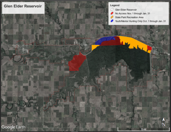
GLEN ELDER - Last Updated: 2/20/2026 Print
| Waterfowl numbers | ALL HUNTERS at Glen Elder WA are required to check-in AND check-out daily. Go to https://ksoutdoors.com/checkin or utilize the GoOutdoorsKS app and check-in using your licensing login credentials. It is YOUR responsibility to know a property's regulations, refuge(s) and duck zone boundaries, etc. BEFORE you hunt. Click here for a detailed map of the refuges, youth area, and State Park boundaries. Please be aware that the Low Plains Early Duck Zone and Low Plains Late Duck Zone boundary is HWY 24. This means Glen Elder WA North of Hwy 24 is in the Early Zone. The majority of the Glen Elder WA (South of HWY 24) is in the Late Zone. --- Lake has opened back up with warmer temps. Due to recent migration activity snow goose numbers are up at the lake. Mallard Migration Rank = 1 (10 is peak migration) ---
|
| Water level | Lake is currently 4.3 feet below conservation. |
| Hunting conditions | Expected to be POOR to FAIR. Currently most areas have vegetation up to the water's edge. Hunters still need to be cautious of DANGEROUS MUD CONDITIONS on the river and creek areas. Ice conditions = none |
| Expected hunting success | Limited potential. |
| Comments | The following boat ramps are currently UNUSABLE due to low water levels: Granite Creek, North Fork River, Carr Creek, Schoen's Cove and Walnut Creek. Low Plains Early Duck Zone (North of Highway 24) season closed for the remainder of the season Low Plains Late Duck Zone (South of Highway 24) season closed Dark geese season closed Whitefront season closed Spring Conservation Order Light geese season Feb. 16 - April. 30, 2026 Cawker City and Granite Creek Refuge closure dates are November 1st - January 31st. The Youth/ Mentor hunting area is located in the Granite Creek Refuge and is in effect from October 1 - January 31. Waterfowl hunting from the shoreline area is allowed in the Youth-Mentor Area as long as EACH adult is hunting with a youth 17 years or younger. Boats of any sort are prohibited in the Granite Creek Refuge. Zebra Mussels have been confirmed in Waconda Lake. Be sure to dry boats and equipment before moving to other waters. |
JAMESTOWN WILDLIFE AREA - Last Updated: 3/28/2026 Print
| Waterfowl numbers | Light geese numbers are changing daily, however there are over 100,000 on the area at any given time. Some days more, some days less. REMEMBER: Hunters are REQUIRED to check-in / check-out here, https://ksoutdoors.com/checkin using your licensing login credentials. |
| Water levels | Managers have started spring drawdowns. The wetlands will have less water week by week, but will not be completely dry until well into the spring. Puddler Marsh: Full. Gamekeeper Marsh: Full; Gun Club West Marsh: 3/4 Full Gun Club East: 3/4Full Greenwing Marsh; 1/2 Full. Marsh Creek Marsh: 1/3 Full, hunters need to be cautious of deep water (over 6') Buffalo Creek Marshes: North marsh has sheet water only, South marsh is almost dry. Pintail Marsh: Dry |
| Hunting conditions | As many light goose hunters know, they are extremely hard to hunt on the water at the marsh. They are leaving the area to feed and returning mid morning and throughout the day. The majority of the birds are using Gamekeeper Marsh. Remember: NO ATV's are allowed on department lands and roads. THIS INCLUDES ARGO'S AND E-BIKES There is a no trash policy: If you take it in with you, please bring it out. This includes spent shotgun shells. THIS REGULATION WILL BE ENFORCED. ALL vehicles must remain on designated roads and parking areas. REFUGE IS OPEN
|
| Expected hunting success | Depends on where the birds are. Success can be had hunting the ag fields on the Wildlife Area, especially during inclement weather days. |
| Comments | Please remember to be cautious while running the boat channels, as there is little to no room for more than one boat at a time. We have had several near collisions and mishaps. Also remember, all boating regulations will be enforced. Navigation lights (red and green bow lights along with an all around white stern light, light bars and headlamps do not qualify), life jackets, passenger capacities and boat registrations (even lay-out boats with a motor) are required.Please remember to be courteous of other hunters on the area and keep music volumes low. Hunters are required to check in and out using your licensing log in credentials in the electronic check-in system online or through the GoOutdoorsKS app. Hunters need to make sure they have all the appropriate licenses and stamps for hunting waterfowl. The following are required: Kansas hunting license State waterfowl stamp Federal waterfowl stamp Kansas Harvest Information Program Stamp (HIP) RINGNECK MARSH IS DESIGNATED FOR YOUTH AND MENTORS ONLY. EACH HUNTER 16 YEARS AND OLDER MUST BE ACCOMPANIED BY ONE OR MORE YOUTH UNDER 16 YEARS OLD. Marsh Creek Marsh is for non-gasoline powered boats or paddle-in / Walk-in only, this includes electric motor boats and boats with no motors. Gasoline engines are prohibited. Buffalo Creek & Pintail Marshes are for non-motorized boats and walk-in hunting only. HUNTERS ARE ENCOURAGED TO :
THE REFUGE IS OPEN UNTIL SEPTEMBER 30, 2026 Please introduce youth and novice hunters to the outdoors. Pass it on! |
LOVEWELL RESERVOIR - Last Updated: 3/12/2026 Print
| Waterfowl numbers | The numbers of light geese using the reservoir as a day roost is greatly reduced, less than 1,000. Numbers vary greatly day to day as there is no snow line north of us so geese are pushing northward for spring migration to the breeding grounds. |
| Mallard Migration Ranking | |
| Water level | Lovewell Reservoir is holding at 1579.6 or 3.0 feet below Conservation Pool,( 73.7% full).The elevation has been near this elevation for the past 90 days. Inflows from the Guide Rock Diversion Canal from the Republican River is being used to refill the reserervoir but no inflow at this time. Irrigation season ended on 9/13. |
| Hunting condition | NO ICE. 100% open water. Hunting conditions during this late winter/early s[ring are heavily dependent on local snow cover and a snow line north of us in Nebraska to halt the migration. There os no snow line. Current water levels have created a mudflat ring around the entire reservoir. Little concealing vegetation is close to the waters edge. No Japanese millet was planted this year due to higher than normal water elevations during the planting season resulting in no mudflats available to seed LOVEWELL RESERVOIR HAS NO WATCHES OR WARNINGS FOR HARMFUL ALGAE BLOOMS. USERS SHOULD STILL BE ON THE LOOKOUT FOR POCKETS OF HARMFUL ALGAE BLOOMS. ALL BOAT RAMPS ARE OPEN, CEDAR POINT IN LOVEWELL STATE PARK, THE MARINA IN THE PARK AND PAWNEE POINT AND OAK HILL ON THE WILDLIFE AREA. WHITE ROCK CREEK AREA IS OUT OF WATER AND CLOSED TO VEHICLES AT THIS ELEVATION. OAK HILL IS AT THE BOTTOM OF THE CONCRETE RAMP AT THIS ELEVATION. USE CAUTION FOR LARGER BOATS AND TRAILERS. ALL BOATS ARE REQUIRED TO USE NAVIGATION LIGHTS WHILE OPERATING BETWEEN THE HOURS OF SUNSET AND SUNRISE. PFD'S MUST NOT BE STOWED IN ANY COMPARTMENT WHILE THE BOAT IS UNDER POWER. KEEP THEM OUT OR BETTER YET ...ON! NON-MOTORIZED BOAT NEED SOME FLASHLIGHT OR LANTERN. |
| Expected hunting success | POOR ON THE WILDLIFE AREA DUE TO THE WARM CONDITIONS. WATERFOWL ARE VERY REFUGE ORIENTED DUE TO PAST AND PRESENT HUNTER AND ANGLER PRESSURE. POOR SUCCESS ON PRIVATE LAND OBTAIN PERMISSION FROM ALL PRIVATE LANDOWNERS BEFORE HUNTING ON ANY OF THEIR PROPERTY |
| Comments | REFUGE REGULATIONS: The land refuge closed to hunting and other activities year-round. Water refuge in effect November 1 through April 15 on the NORTHEAST half of the reservoir and Wildlife Area from 1/8th mile west of the south end of the dam and following a buoy line northwest to the western boundary of the Cabin Area of the State Park. This area open to fishing south and east of the buoy line from the north end of the dam to the Lovewell State Park Twin Coves trailer area. Inlet canal closed to fishing September 15 through April 15. BOAT RAMPS: SEE HUNTING CONDITION FOR BOAT RAMP STATUS. The State Park boat ramps require a Kansas State Park Permit. The Wildlife Area Boat Ramps are Pawnee Point, Oak Hill and White Rock Creek do not require a permit. CAMPING CABINS are available in Lovewell State Park. Make reservations HERE HUNTERS ARE ENCOURAGED TO :
FOLLOWING SAFE AND ETHICAL PRACTICES WILL ENSURE THAT EVERYONE HUNTING PUBLIC LANDS ENJOYS A HIGH-QUALITY EXPERIENCE. Hunters can check-in / check-out here, https://license.gooutdoorskansas.com using your licensing login credentials. Contact the office for other arrangements. We thank you for your patience. Please introduce youth and novice hunters to the outdoors. Pass it on! |
NORTON - Last Updated: 1/27/2026 Print
SMOKY HILL/KANOPOLIS - Last Updated: 1/15/2026 Print
| Waterfowl numbers | Waterfowl numbers have been lower than average for this time of year. Goldeneye and mallard numbers are moderate. Geese numbers are moderate in the area with birds primarily feeding on private lands. |
| Water level | 1461 |
| Hunting conditions | Poor around reservoir with low water levels resulting in exposed shoreline |
| Comments | Refuge is CLOSED to all access from September 1st through January 31st. |
TALMO - Last Updated: 1/9/2026 Print
| Waterfowl numbers | No waterfowl observed on the area. All pools are dry.
REMINDER: ALL HUNTERS NEED TO CHECK-IN / CHECK-OUT. Click here, https://ksoutdoors.com/checkin using your licensing |
| Water level | ALL POOLS ARE CURRENTLY DRY |
| Hunting conditions | Poor with no water |
| Expected hunting success | Will depend upon rainfall. |
| Comments | Remember: - TALMO IS IN THE LOW PLAINS LATE ZONE TALMO IS IN THE CLOSED SANDHILL CRANE ZONE
- Hunters can Check-in / Check-out here, https://ksoutdoors.com/checkin using your licensing login credentials. - No ATV's are allowed on Department land and maintained roads. -ALL shotgun hunters must use NON-TOXIC shot -No motorized boats allowed. Hunters wanting to utilize boats must carry/paddle them in. -The area has a no trash policy. If you take it in, please bring it back out with you. This includes spent shotgun shells. -ALL vehicles MUST remain on the roads and designated parking areas only. |
WEBSTER - Last Updated: 1/13/2026 Print
| Waterfowl numbers | Waterfowl numbers have been relatively stable over the past couple weeks. Birds are mostly loafing in the refuge during the daytime hours. We started observing sick snow geese as soon as they showed up at Webster and submitted samples for testing. I will update here with the test results as soon as SCWDS completes their testing protocols. |
| Water level | 1866.7'; 25.8' below conservation pool. |
| Hunting conditions | Minimal inflow occurred during this Summer and Webster is still very low. Shorelines revegetated to some degree this growing season however there is very little flooded vegetation. The West end of the reservoir has a very silty, soft bottom. The mud is knee deep. |
| Expected hunting success | Poor Boaters: Please be aware of shallow water if using a boat for waterfowl hunting. Many areas near shorelines are very shallow. There are also some humps and high spots that are just out of visibility right below the surface. |
| Comments | Refuge and non-motorized boat area dates: Nov. 1 through Jan. 31. Morel boat ramp is currently dry. The Rockpoint boat ramp within the State Park is accessible. Hunters need a park pass to access boat ramps in the state park. Hunting in or from the shoreline inside the State Park or along the face of the dam is prohibited. Closed areas will be marked with buoys. Refuge boundaries are posted around the area, in the state park office or on the OnX Hunt app. REMINDER: Camping is not permitted on the wildlife area, including in parking lots, except for in designated campgrounds. Ground fires are also not permitted except in provided fire rings within campgrounds. Blue/Green Algae There are currently no blue-green algae advisories for the lake. Webster Reservoir currently does not have zebra mussels. Please be sure equipment is cleaned and dry before coming to Webster from other places. Teal Season - Low Plains September 13, 2025- September 21, 2025 Duck Season on Webster Reservoir - Low Plains Late Zone November 1, 2025 - January 4, 2026 and January 17-25, 2026 Youth Weekend, Duck and Goose October 18-29, 2025 Goose Season on Webster Reservoir CANADA GEESE November 1-2, 2025 and November 5, 2025 - February 15, 2026 WHITE-FRONTED November 1, 2024 - January 4, 2026 and January 24 - February 15, 2026 LIGHT GEESE November 1-2, 2025 and November 5, 2025 - February 15, 2026 Sandhill Crane Season on Webster Reservoir - Central Crane Zone November 5, 2025 - January 1, 2026 LIGHT GOOSE CONSERVATION ORDER February 16 - April 30, 2026
Webster Wildlife Area and Refuge Map |
WILSON - Last Updated: 1/15/2026 Print
| Waterfowl numbers | Duck numbers are low for this time of year. Few mallards and goldeneyes have been observed. Canada geese numbers are generally low, but increasing. Majority of geese are utilizing private lands. |
| Water level | 5 ft low |
| Hunting conditions | Cedar Creek boat ramp is dry and inaccessible; Limited access at Elm Creek Boat Ramp. There is no check-in or check-out to hunt Public Lands at Wilson Wildlife Area. |
| Expected hunting success | Limited with low water levels |
| Comments | Refuges are closed Sept 1-Jan 31 to all access except by special permit. This includes land and water refuge areas. Teal Season - Low Plains September 13, 2025 - September 21, 2025 |
This is a collection of all the Northeast Waterfowl Reports
BENEDICTINE WILDLIFE AREA - Last Updated: 9/11/2025 Print
| Waterfowl numbers | Mallard Migration Rank: 1 (Estimate of potential mallard numbers. 1=lowest, 10=highest) No ducks observed using the area currently. |
| Water level | A map of our wetlands is now available under the Wetland Map tab to the right. The wetlands have great habitat such as, Giant Foxtail, Annual Smartweed, Barnyard grass, and sunflowers. We have pumped the northern section of Headquarters Marsh straight West of the office. Refuge (NOT open to hunting) October 1 through March 31 the area can only be accessed with a special permit obtained through a drawing. Look for "Special Hunts" on our home page under "HUNTING". |
| Hunting conditions | Native vegetation such as annual smart weeds, barnyard grass, foxtail, and sunflowers are the most common vegetation. |
| Expected hunting success | Hasn't been many ducks using the hurtable wetland. |
| Comments | The furthest West wetland has not been pumped and we are waiting for pump repairs before we will be able to use it. |
CLINTON - Last Updated: 1/16/2026 Print
| Waterfowl | Waterfowl numbers slightly higher than last survey. (1/16/26)
|
| Lake level | Lake Level is 875.66 Conservation Pool is 875.50 Clinton Wildlife Area Refuge is Open (Closed October 1-January 15) |
| Hunting conditions | Wetland Pools ALL WETLAND POOLS ARE CURRENTLY ICE FREE- *As of 1/16/25* Forecasted arctic conditions will freeze most pools up. Coblentz - All pools are full. Good millet and smartweed with perimeter rows of standing corn and some sorghums. Be mindful of deep water around structures on East side of Southeast and middle pools and in waterways. Pump is off. East Coblentz- Full. Food sources in pool are beggar's ticks and smartweed with some millet. Deep, open pool on Northeast side of marsh past berm. Shadden- "Little Shadden" (South of Wakarusa) mostly dry, with millets and smartweed; filled by rainfall only. "Big Shadden" South pool- mostly dry, standing and cut corn; North pool- less than 1/4 filled, with water in low spots. Good millet with standing/harvested corn on perimeter of newly constructed marsh (on the North side of Wakarusa river.) Open to hunting, needs rainfall for more huntable water. Elk Creek- Elk Creek pools are mostly dry, with water in low spots. See below. *A portion of the funding for long-needed Elk Creek marsh renovations was recently allocated from KDHE with the unfortunate expiration date of 12/31/2025. The water levels had to be dropped enough to set new control structures, drainage pipes, and complete grading and dirt work. Again, the timing is extremely unfortunate, and staff remains dedicated to making lasting improvements to the quality and overall amount of public waterfowl hunting available at Clinton Wildlife Area.* The Refuge pool is roughly 1/2 to 3/4 filled. Elk creek marsh pools are numbered from West to East, with pool 1 next to Elk Creek boat ramp and parking lot. Food: moist-soil vegetation- millets, smartweed, and beggar's ticks. Cut corn with rows left standing in pools 1, 2, and 3. *Additional rainfall* and colder weather may change conditions throughout the property, as well as local waterfowl numbers rapidly. -Recent rains are filling some tributaries and should help starting to fill some rain-filled only marshes and oxbows. Lake- Lake level is just above normal pool. As of 1/16/26, there is NO ICE on lake. That will change with cold conditions. Expect shallow, exposed areas to be frozen within 24 hours of this update. There are many shallow areas of the lake that offer mudflats for waterfowl hunting opportunities. Seed-producing vegetation grew in many of the dried lake edges as the levels dropped. Wildlife Area REFUGE is currently OPEN. Clinton W.A. Refuge will be CLOSED FROM OCTOBER 1ST, 2025 TO JANUARY 15TH, 2026. Please look for signage and the line indicating the Western Refuge boundary. It runs North and South along the back side of pool 3. The East Refuge boundary extends 1/2 mile east of County Rd. 1023, running parallel to the road, across the Wakarusa arm of Clinton reservoir. KDWP 2025-2026 Online Hunting Atlas Clinton contains miles of creeks, rivers and oxbows on the wildlife area; each of which has unique conditions and frequently hold waterfowl when weather and/or hunting pressure pushes them from marsh pools.
|
| Expected hunting success | Poor to fair |
| Comments | IMPORTANT! Clinton Wildlife Area is utilizing an electronic check-in system required of all hunters. To check-in / check-out, please go to https://ksoutdoors.com/checkin using your licensing login credentials. Please remember that trapping is also allowed on the Wildlife Area. Elk Creek (Wakarusa River) and Coon Creek (Lake) boat ramps are open. Rock Creek Boat ramp is closed; a gravel launch area for canoes and kayaks is available when lake is above normal reservoir pool (875.5). |
HILLSDALE - Last Updated: 2/10/2025 Print
| Waterfowl Numbers | The Hillsdale Wildlife Area has experienced a relatively dry year in regards to water levels in 2024. The reservoir currently sits 2 feet below conservation pool. Due to the low water level of Hillsdale Reservoir, the wetlands were unable to be pumped this year. ALL WETLANDS ARE DRY. Waterfowl counts given on this report are based on what was observed on the day the report is updated. Waterfowl numbers vary greatly from day to day and weather conditions and hunting pressure will affect the numbers of waterfowl on the area. A waterfowl survey was conducted on 2/10/2025. The survey showed around 40 Canada geese on Hillsdale reservoir. Around 25 mallards, 75 goldeneye, 10 bufflehead, and 20 unidentified divers were also seen. |
| Water Level | Antioch Wetland - Empty Browns Wetland, Upper pool - Empty Browns Wetland, Lower pool - Empty Youth-Mentor Wetland - Empty Wade Branch Wetlands - North - Low, South - Low Hillsdale Lake - See Army Corps Daily Report ICE CONDITION - 70% ice cover on lake. 0% ice cover on wetlands |
| Comments | Reminder - check-in / check-out is required for all hunting on Hillsdale Wildlife Area. This can be done here, https://ksoutdoors.com/checkin using your licensing login credentials. The information and harvest data collected, along with comments received are very useful in establishing future management goals for the Hillsdale State Wildlife Area. https://www.ksoutdoors.com/Hunting/Migratory-Birds/Ducks for more information on seasons and limits. |
JEFFREY ENERGY CENTER - Last Updated: 3/24/2026 Print
| Waterfowl numbers | Ducks: <150 mixed ducks on area Geese: Snow goose numbers are hovering right around 100,000 on area. Canada geese numbers are <100. |
| Water level | Normal |
| Hunting conditions | Fair |
| Expected hunting success | Fair |
| Comments | Make-up Lake is closed to waterfowl hunting during waterfowl season. Boats are not allowed on Auxillary lake during waterfowl season. Individuals wishing to hunt Unit #2 of the wildlife area must enter through the main gate and sign in at the guard house. Be sure to have a photo I.D. with you when checking in. Hunters are required to drive maintained roads only. A map will be provided to all hunters showing open roads as well as parking areas. Vehicles are allowed to park in parking areas only. Avian influenza in snow geese has been reported on the area and areas surrounding the Auxillary lake. Additional information related to avian influenza can be viewed in the links below. |
MILFORD WILDLIFE AREA - Last Updated: 1/9/2026 Print
| Waterfowl numbers | WATERFOWL REPORT UPDATED: 01/09/2025 Mainly goldeneyes and Canada Geese using the main lake. A few mallards and gadwall were observed. Seeing an uptick in geese numbers on the lake as well. Abnormally low numbers of waterfowl on the area for this time of year. REMEMBER: Hunters are REQUIRED to check-in / check-out here, https://ksoutdoors.com/checkin using your licensing login credentials. |
| Water Levels | Current Lake Level is 1,143.27 and Conservation Pool is 1144.4 The dam is releasing 400 CFS. The inflow into the lake is 850 CFS. Sugarbowl is full. Quimby is full. |
| Hunting conditions | Vegetation growth and seed production has been above average this year with the amount of moisture we have received throughout the summer. Pockets of thick vegetation present in some wetlands that could result in difficulty finding down birds. 0% Ice Cover No activities/hunting allowed in the Steve Lloyd Wetland/Refuge. Motorized boats are only allowed in the Mall Creek wetland, electric motors are considered "motorized". All other public hunting wetlands are open to NON motorized boats and walk in hunting. |
| Expected hunting success | Fair. Moist soil plants will provide great habitat and food for this year. |
| Comments | -------------------------------------------------------------------------------------------------------------------------------------------------------------------------------------------------------------------------------------------------------------- Do NOT drive on dikes. Vehicles disrupt and discourage waterfowl from using the wetland areas. We have had several dikes being damaged due to unauthorized vehicles driving on them. Scouting is best done on foot to evaluate bird numbers and habitat conditions. Please report any vehicles on dikes and anyone seen disturbing our pumps. Without the pumps in optimal condition we are unable to pump the wetlands to their greatest potential. Do NOT block gates, and pay attention to No Parking signs in the wetland parking lots. Hunter's need to be aware of their targets before shooting. The area is a no trash policy, so if you take it in, please bring it back out with you. This includes spent shotgun shells Fires are not permitted anywhere on the wildlife area. Violators will be ticketed Remember - Hunters can check-in / check-out here, https://license.gooutdoorskansas.com/. All hunters (youth included) must first register online. The information collected and comments received are very useful in establishing future management goals for the area. https://www.ksoutdoors.com/Hunting/Migratory-Birds/Ducks for more information on seasons and limits. |
PERRY WILDLIFE AREA - Last Updated: 12/29/2025 Print
| Waterfowl Updates | A waterfowl survey was conducted on 12/29/25 and wetlands are mostly froze over but the Delaware River is open. Large concentrations of divers on big open water around Lake Perry. We will likely be dealing with some ice coverage for a while with the weather forecasts.
ATTENTION WATERFOWL HUNTERS - LEGAL SHOOTING LIGHT IS FROM 3O MINUTES BEFORE SUNRISE TO SUNSET. *DON'T FORGET TO CHECK-IN / CHECK-OUT HERE, https://ksoutdoors.com/checkin using your licensing login credentials.
|
| Lake level | 2.36 Feet Above Conservation Pool |
| Habitat conditions | Mild flooding in the spring, followed by a dry spell for the bulk of the middle of the summer allowed for a great amount of pool work and supplemental food such as Japanese Millet and Sorghum strips being planted in multiple wetlands. Rains in the later half of the summer encouraged good native moist soil vegetation and helped with the vegetation planted as well.
|
| Comments | Habitat Condition Rating (HCR): 1-10; 1-Poor habitat, 5-quality habitat, 10-Exceptional habitat Reminder: Gas powered boats are only allowed on the River, Lake, Sunset Ridge, Kyle East and West and Rucker wetland pools. Electric powered boats are allowed in all marsh pools. Kyle: Pumping is complete and the East and West Units are 100% full. Utilized a drone to spray most of the invasive River Bulrush in the East unit of Kyle, but no mechanical manipulation was done due to wet conditions throughout the summer. HCR-5 West River: A significant amount of the upper and lower unit of West River as disked and planted to Japanese Millet with some sorghum strips throughout. In the lower unit, we utilized a drone to spray most of the invasive River Bulrush on the West side of the drainage ditch which did promote some growth of native moist soil vegetation underneath as the rush died down. Some pumping has been done and will continue throughout season with a good amount of huntable water in the upper unit and the middle of the lower unit and some water starting to show down at the lower levee. HCR-8 Upper Ferguson: This wetland grew mostly native smartweed and has little water currently. The water control structure is currently removed and a new one is expected to be here to install in the next couple months or so. The refuge is closed Oct 1st thru Jan 15th to ALL Activity HCR-6. Lassiter: Water was held all year in both the East and West Unit of Lassiter which led to a large amount of perennial vegetation growth making the wetland fairly thick in the early season. Little open water is available until some of the vegetation starts to die down this fall/winter. Full pool. HCR-5 Northwest: This unit was mostly planted to corn and pumping is complete. 100% full. The area not planted to corn was mostly disked and planted to Japanese Millet with sorghum strips in it as well. HCR-7 Headquarters: Corn was planted in this marsh and boards are in the structure awaiting rainfall to fill. No water currently. HCR-7 Mitigation: Unit was drawn down this year to improve the access trail and mow down some of the thick perennial vegetation and trees that started to develop. No water collected yet. HCR-7 Hayward: Unit was drawn down and large portions of it disked and planted to Japanese Millet with some native moist soil vegetation response as well. No water collected yet. HCR-8 Reichart: Water was held in the NW Unit of Reichart and is near full now with marginal wetland vegetation because of holding water all summer. The rest of Reichart has been pumped and has Corn on the NE end and native moist soil vegetation throughout the rest of the marsh. Full pool. HCR-8. Zebra Mussels have been confirmed in the lake. Be sure to dry boats and equipment before moving to other waters. Please remember to fill out the permit with accurate information. THIS INFORMATION IS VERY IMPORTANT TO THE CURRENT AND FUTURE MANAGEMENT OF THE AREA. FILL OUT ONLY YOUR INDIVIDUAL HARVEST EFFORTS, i.e., NOT A GROUP HARVEST TOTAL. |
TUTTLE CREEK WILDLIFE AREA - Last Updated: 1/16/2026 Print
| Waterfowl numbers | Waterfowl numbers have been below average throughout week from last week when a average amount of waterfowl were around. Most of the waterfowl numbers have been viewed along the river. Most of the wetlands have been locked up with ice, thought the past week and this week. Black Vermillion has a good amount of water in the north pod and the south pod is being pumped into at this time. Some open water with the wind from the past days and upcoming weather, some water pockets might stay open. |
| Water level | The lake is currently at 1078.28 which is 3.28' above conservation pool level. Out flow is 800 cfs and inflow is 364 cfs. Water levels are becoming a little more shallow with the lake level decreasing. Black Vermillion has good water levels for both north and south pod is being pumped into at this time. Olsburg and Irving Marsh are the only two marshes that does not have water. |
| Hunting conditions | Fair to poor-moist soil production and abundant flooded vegetation was good throughout but as of now, low water levels and few areas are very shallow and have been locked up due to ice. |
| Expected hunting success | Poor. Reminder to make sure waterfowl are being identified and watch for other hunters. |
| Comments | Please check in using https://ksoutdoors.com/checkin prior to hunting Tuttle Creek Wildlife Area. Please be aware of the water level for boat use and ramps along the area. Hunters are encouraged to:
The bridge on Rolander Rd. is closed and shut down along the road. |
This is a collection of all the Southwest Waterfowl Report
CHEYENNE BOTTOMS - Last Updated: 3/9/2026 Print
| Waterfowl numbers | Low numbers of snow geese left. Good number and diversity of ducks. If the report has not been updated in a few days, please assume that conditions and bird numbers are the same as the last update. |
| Water level | Pool 1A-57", Pool 1B-25", Pool 1C-25" Pool 2-12" Pool 3A-13" Pool 3B-dry, Pool 4A-2" Pool 4B-6" Pool 5-2". Currently pumping water from exterior pools to interior storage pools. Cheyenne Bottoms has no ground water pumps to fill pools. |
| Hunting conditions | Pool 2- 60 acres of wheat in the pool. Blind islands are being rebuilt as conditions allow. Pool 3B- 46 acres of wheat planted fall of 2025, 135 acres of standing wheat. Pool is being disced in preparation for next spring. Pool 3A- decent moist soil production. Hunting holes and access trails mowed throughout. 4A- decent moist soil production. Hunting holes and access trails mowed throughout. 4B- 75 acres of millet planted, fair food production. Hunting holes and access trails mowed throughout. 5- good food production. All blind islands in 3A, 3B, 4A, and 4B have been rebuilt. |
| Expected hunting success | Fair. Food production is fair. Will have more water than anticipated in the hunting pools that will help the hunting conditions. Hunting success has varied greatly depending on the weather. Ducks are in the nocturnal pattern on most days. |
| Comments | HUNTERS CAN CHECK IN VIA THE GOOUTDOORSKS APP OR THE WEBSITE. ALL BOATS MUST BE OPERATED AT NO WAKE SPEEDS. ALL BOATS MUST BE OPERATED AT NO WAKE SPEEDS 100% OF THE TIME, NO EXCEPTIONS. POOL 4A IS CLOSED AT 1 P.M. DAILY TO MOTORIZED BOATS. ANY BOAT WITH A MOTOR ON IT MUST BE OUT OF THE WATER AT 1 P.M. NO MOTORING OUT PRIOR TO 1 P.M. THEN ROWING OR DRAGGING BOAT BACK IN AFTER 1 P.M. 3A IS CLOSED TO MOTORIZED BOATS NO WATER VESSELS , MOTORIZED OR NONMOTORIZED, ALLOWED EXCEPT DURING AN OPEN WATERFOWL SEASON. DURING THE YOUTH/VETERANS/MILITARY WEEKEND, POOL 4B IS DESIGNATED AS A YOUTH ONLY POOL. LEGAL SHOOTING HOURS ARE 30 MINUTES BEFORE SUNRISE TO SUNSET. UNLAWFUL TO SHOOT FROM ROADS OR DIKES ON THE WILDLIFE AREA. DO NOT PARK BLOCKING ROADS, GATES, BOAT RAMPS, FOOT CROSSINGS, ETC. DO NOT LAUNCH TRAILERED BOATS FROM DIKES OR FOOT CROSSINGS. ANY BOATS ON A TRAILER MUST USE DESIGNATED BOAT RAMPS. NO TRASH POLICY ON THE WILDLIFE AREA. CAMP IN DESIGNATED CAMPGROUND ONLY Use footcrossings in Pools 2, 3A, 3B, 4A, and 4B as the ditches have been cleaned out and are very deep. For waterfowl season dates, Cheyenne Bottoms is in the Low Plains Early Zone. |
ISABEL - Last Updated: 1/22/2026 Print
| Waterfowl numbers | No waterfowl observed 1/22. |
| Water level | The main lake is nearly full. The pool south of the main lake is full and the pool to the east of that has some water. The pool along Hwy. 42 is full. |
| Hunting conditions | The 2nd segment of the Low Plains Late Zone is 1/17 to 1/25. |
| Expected hunting success | 75% ice-covered on 1/22 with cold weather forecast through the weekend. |
| Comments | Teal Season (Low Plains Zone): September 13 - September 21, 2025 Youth, Veteran, Active Military Waterfowl (Low Plains Late Zone): October 18-19, 2025 Ducks (Low Plains Late Zone): November 1, 2025 - January 4, 2026 (first segment) and January 17, 2026 - January 25, 2026 (second segment) Daily check-in and harvest reporting is required Check-in/Check-out on The Web
Check-in/Check-out on The App
Only non-toxic shot is allowed on Isabel Wetland Wildlife Area for all species. |
TEXAS LAKE - Last Updated: 1/9/2026 Print
| Waterfowl numbers | Mallards and Pintails present 1/8/26. |
| Water levels | Pools 1 and 2 are nearly full. Pools on the west side of the area have dried some, but pools 6 and 8 have water. |
| Hunting conditions | Duck season (Low Plains Early Zone) has closed. |
| Expected hunting success | |
| Comments | Teal Season (Low Plains Zone): 9/13/25 - 9/21/25 Youth, Veteran, Active Military Waterfowl (Low Plains Early Zone): 9/27/25 & 9/28/25 Regular Ducks (Low Plains Early Zone): 10/11/25 - 12/7/25 and 12/20/25 -1/4/26 Daily check-in and harvest reporting is required Check-in/Check-out on The Web
Check-in/Check-out on The App
Only non-toxic shot is allowed for all shotgun hunting at Texas Lake Wildlife Area. |
This is a collection of all the South Central Waterfowl Reports
CHENEY - Last Updated: 2/5/2026 Print
| Waterfowl numbers | Large numbers of geese (Canada, White Front, and Snow) have moved onto the reservoir. Reminder: LPLZ duck season closes 1/25/26 and White Fronted Geese open back up 1/24/26 |
| Water level | Lake level is 1.4 ft above conservation pool |
| Hunting conditions | Good: 3 years of vegetation growth around the lake shore is now flooded. Water is standing in many natural wetlands with good moist soil vegetation. Stop logs have been placed in new control structure in Redbluff wetland and water levels will increase as the area gets precipitation. |
| Expected hunting success | Poor |
| Comments | Vehicles are not to be driven on the lakebed. This includes UTV, ATV, and E-Bikes. Hunters, please remember there is Phragmites and Salt Cedar on the lakebed. Do not move these plants for blind material or take them from the lake to brush in layout blinds. Cheney Wildlife Area is located in the Low Plains Late Zone Daily bag limit: 6 Six ducks is the daily bag limit, with species and sex restrictions as follows: 5 mallards (no more than 2 of which may be females), 3 wood ducks, 2 redheads, 2 canvasbacks, 1 pintail, and 1 scaup. The daily bag may comprise six of any other duck, such as six teal, six gadwall, six merganser or six wigeon. Possession limit: Three times the daily limit. The refuge at Cheney Wildlife Area, located on the south side of Pretty Prairie Rd between Obee Rd and Kent Rd, extends out from the shoreline about 100 yards into the water. What this means is that water along the shoreline of the refuge is included in the restricted access area and is off limits to hunting. Accessing the refuge by boat or hunting near the refuge shoreline is not permitted. Hunting in the state park is prohibited. Hunting in the campground areas must be done inside the line where water would be at conservation pool. Remember Cheney Reservoir has ZEBRA MUSSELS. Make sure to Clean, Drain and Dry your equipment. Clean all visible vegetation and mud from decoys, bags, waders, etc. Drain water from decoy bags and boats. Allow equipment to Dry for a five day period before using it at another area, OR wash with high-pressure hot water. Many of the roads around the reservoir can get very greasy after rain, or melting snow, please use good judgement about which roads you try to travel on. Area roads have been upgraded with gravel. Please keep vehicles on maintained road and parking areas. Off road vehicle use is strictly prohibited. Please report all wildlife and public lands violations that you witness by calling the area headquarters at (620) 459-6922 or operation game thief at 1-877-426-3843. Please leave a detailed message with violation specifics. In the event of an emergency, please call 911. |
BYRON WALKER - Last Updated: 9/17/2025 Print
| Waterfowl numbers | Teal moved in early preseason with the cool temperatures, then left when the weather warmed again. Currently, few teal are using the area. |
| Water level | Kingman State Lake is completely full. The big marsh just west of the lake is flooded and the new Headquarters marsh east of the area office is currently being flooded. Important to note, access for the Headquarters marsh must be from the north or east. You cannot park in or walk through the refuge to access the hunting area. |
| Hunting conditions | Good.
|
| Expected hunting success | Poor. Coming cold fronts could bring in new migrants. |
| Comments |
COUNCIL GROVE - Last Updated: 2/17/2026 Print
| Waterfowl numbers | No snow geese observed. |
| Water levels | 1.3 feet below conservation elevation (1,274') on 2/17/26. |
| Hunting conditions | The lake remained full through September. Moist soil plants are absent along lake fringes. As such, few food resources will be available for waterfowl within lake environments. |
| Expected hunting success | Poor. |
| Comments | Duck and dark goose seasons are CLOSED. Spring Conservation Order for Light Geese is open through April 30. |
EL DORADO - Last Updated: 1/9/2026 Print
| Waterfowl Numbers | Duck numbers remain low on the reservoir. Fair numbers of geese observed in the area. |
| Water level | At 1339.15', approximately .15" above conservation elevation (1339'). |
| Hunting conditions | Fair. The reservoir was in flood stage for the entire growing season. There is very little moist soil vegetation in the reservoir due to the high-water conditions. |
| Expected hunting success | Poor |
| Comments | NOTE: El Dorado Lake is located within the Low Plains Southeast Zone. |
KAW WILDLIFE AREA. - Last Updated: 1/22/2026 Print
| Waterfowl numbers | There are some ducks and geese using the area. River was slushy with ice pieces. |
| Water level | Normal |
| Hunting conditions | Poor |
| Comments | TEAL, LOW PLAINS ZONE Season: Sept. 13-21, 2024 Area open: East of Hwy. U. S. 283 Daily bag limit:6 Possession limit:18 Stamps Required: Kansas HIP Stamp, State Waterfowl Stamp, Federal Waterfowl Stamp DUCKS, LOW PLAINS SOUTHEAST ZONE Season: November 08, 2025 - January 4, 2026, AND January 10-25, 2026 Area open: Southeast Zone (see map) Daily bag limit:6 Possession limit: Three times the daily limit |
MCPHERSON VALLEY WETLANDS - Last Updated: 2/6/2026 Print
| Waterfowl numbers | ATTENTION: All hunters MUST check-in / check-out when hunting. Visit https://ksoutdoors.com/checkin using your licensing login credentials to check in and out. February 6th, 2026: Another duck season has come and gone. The LPEZ duck season is now closed. Canada, whitefront, and snow goose seasons are open. All goose seasons close February 15th, 2026. The snow goose conservation order takes effect February 16th, 2026. The majority of the geese left the area during the stretch of cold weather and ice cover. A few geese are starting to return to the area, but there is very little open water at the time of this update. Waterfowl numbers can fluctuate greatly from day to day depending on ice cover, weather, and other factors. Remember: the North Refuge in the Big Basin is in effect from Oct. 1st to April 1st. All activities in the south refuge in the Big Basin are prohibited year round. |
| Current Information | Due to wet conditions this year: be prepared for un-mowed dikes and access trails, flood damaged parking lots / emergency spillways, and robust wetland vegetation. Be aware of three new regulations in effect at McPherson Valley Wetlands: (1) The Big Basin has been designated as "youth only" during the youth and military waterfowl weekend, (2) the use of motorized boats is prohibited, and (3) centerfire rifles and handguns are prohibited. |
| Water levels | Pumping operations at the Little Sinkhole and Big Basin are now complete for the 2025 - 2026 season. Big Basin: ~70% capacity. Chain of Lakes: ~20% capacity. Little Sinkhole Marshes: ~70% capacity. At the time of this posting, the wetlands were still near 100% frozen and thawing slowly. |
| Hunting conditions | Difficult due to melting ice. |
| Expected hunting success | Poor, but could improve quickly, depending upon ice and weather conditions. |
| Comments | **ATTENTION: **THERE IS A "NO TRASH POLICY" IN EFFECT AT MCPHERSON VALLEY WETLANDS. PLEASE CARRY OUT WHATEVER YOU CARRY IN, INCLUDING EMPTY HULLS AND OTHER TRASH. PLEASE TRY TO LEAVE YOUR HUNTING SPOT AS CLEAN OR CLEANER THAN IT WAS WHEN YOU ARRIVED. THANKS!!! **REFUGE AREAS: THE SOUTH REFUGE AREA IN THE BIG BASIN IS OFF-LIMITS TO ALL ACTIVITIES ALL YEAR LONG, AND THIS INCLUDES DUCK HUNTING. THERE IS NO HUNTING OR PUBLIC ACCESS OF ANY KIND ALLOWED IN THE SOUTH REFUGE IN THE BIG BASIN!! THE NORTH REFUGE IN THE BIG BASIN IS A REFUGE-IN-TIME AND IS ONLY OPEN TO PUBLIC ACCESS FROM APRIL 1ST UNTIL SEPTEMBER 30TH, THEN IT IS CLOSED TO ALL ACTIVITIES FROM OCTOBER 1ST TO MARCH 31ST. The Little Sinkhole/Farland Lake marsh unit is included in the EARLY low-plains duck zone (as is the rest of MPWL). All shotgun hunters at McPherson Wetlands are required to use non-toxic shot for all hunting. This includes upland birds. Throughout all units, please be mindful of farmers and big equipment operators needing to access and maintain roads. Park in designated parking areas when possible, and not on the roadsides. |
SLATE CREEK WETLAND - Last Updated: 1/22/2026 Print
|
Waterfowl numbers | There are not very many ducks and geese on in the area at this time. All the pools have water in them and cover with 80% of ice. |
|
Water level | Normal |
| Hunting conditions | Poor |
| Comments | Slate Creek Wetland Hunters can check-in / check-out here, using your licensing login credentials. https://license.gooutdoorskansas.com/ TEAL, LOW PLAINS ZONE
DUCKS, LOW PLAINS LATE ZONE
Also, all shotgun hunters at Slate Creek Wetlands are required to use non-toxic shot for all hunting. This includes upland birds.
|
https://license.gooutdoorskansas.com/
MARION - Last Updated: 2/12/2026 Print
| Migration | Migration is slowing with even numbers of puddle ducks and divers on the reservoir. Numbers can change daily |
| Ice | 70% |
| Water level | Lake level is at 1350.49 (Conservation pool is 1350.50) |
| Hunting conditions | Fair. The reservoir was in flood stage or conservation pool during the growing season so moist soil vegetation didn't get a chance to take hold this year around the reservoir, limiting food sources. Crops around the area did well this year due to ample rain through the summer. The reservoir remains near conservation pool making shoreline cover abundant. |
| Expected hunting success | Poor. |
| Comments | The refuge at Marion Wildlife area, located on the south west part of the reservoir along French creek, extends out from the shoreline 100 yards into the water. What this means is that approximately 110 acres of water along the shoreline of the refuge are included in the restricted access area, and are off limits to hunting. Accessing the refuge by boat or hunting near the refuge shoreline is not permitted. Remember Marion Reservoir has ZEBRA MUSSELS. Make sure to Clean, Drain and Dry your equipment. Clean all visible vegetation and mud from decoys, bags, waders, etc. Drain water from decoy bags and boats. Allow equipment to Dry for a five day period before using it at another area, OR wash with high-pressure hot water. Many of the roads around the reservoir can get very greasy after rain, or melting snow, please use good judgement about which roads you try to travel on. |
This a collection of all the Southeast Waterfowl Reports.
ELK CITY RESERVOIR/WILDLIFE AREA - Last Updated: 1/5/2026 Print
| Waterfowl numbers | Waterfowl numbers fluctuate with migration, hunting pressure, and changing habitat conditions. |
| Water level | We had quite a bit of rainfall in the fall. Water started being held in July in some wetlands and another rain event in late August added to the water levels in most wetlands. Wetlands range from very little water to being full. All of them have enough water for ducks to utilize with only a couple of exceptions. The lake is 0.49 ft above conservation pool right now. For current Reservoir levels visit http://www.swt-wc.usace.army.mil/ELKC.lakepage.html |
| Hunting conditions | The vegetative growth is good in most wetlands. The lake edge also has good growth, but the water level in the lake jumped up several times this summer so most areas of vegetation will require the lake to be several feet above pool level in order for the food source to be flooded for waterfowl. Food production was variable across the wetlands but much better than the last couple of years. |
| Expected hunting success | Variable. TEAL SEASON IS SEPT. 13-21 REGULAR DUCK SEASON IS NOV. 8-JAN. 4 AND JAN. 10-25 |
| Comments | Please do not leave trash on the public ground including empty shells. Individuals utilizing the wildlife area need to be aware of the refuge boundaries. Boats cannot drive through the refuge area on the water. Maps can be obtained at the Fisheries & Wildlife office (below the dam), at the State Park (on the lake side), and online at https://ksoutdoors.com/content/download/20944/140278/file/ELK%20CITY%20RES%20&%20WA.pdf |
FALL RIVER RESERVOIR - Last Updated: 1/20/2026 Print
| Waterfowl numbers | 01/20/26 Low numbers of dabblers on the lake at any given time along with groups of divers. |
| Water level | Lake level is 0.27 feet above normal pool. Many area marshes are dry or extremely shallow. |
| Hunting conditions | High water levels throughout the summer have hindered mud flat herbaceous growth. Conditions are going to be most promising around the main lake body until the ice melts. |
| Expected hunting success | Fair |
| Comments | Waterfowl reports will be updated on a bi-weekly basis during the fall and winter waterfowl seasons. Updates will be made when significant changes in waterfowl numbers are observed. For information pertaining to the Fall River Wildlife Area call 785-260-3722. |
JOHN REDMOND - Last Updated: 12/9/2024 Print
MARAIS DES CYGNES - Last Updated: 2/7/2026 Print
| Waterfowl Observed | mallard, Canada goose, white fronted goose
|
| Water Levels | 80% Ice around 2" or less and rotten. Water Level Gauges: A-North (Reese Lake/north structure): 27" A-North (middle structure): 41" A-North (south structure): 35" A-East at ramp: 21" A-East at outlet: 35" C-South at outlet: 33" Unit D wetlands: mid elevations of some units Unit E wetlands: low elevations F-East at outlet: 39" F-South at outlet: 17" F-West at outlet: 18" Unit G: 22" Unit H: low to mid elevations Refuge Units: B-North: 28" B-South: 37" C-North: 29" Staff use these gauges to help manage water levels through both pumping and drawdowns. We will try to provide the level of water as it reads on the gauge. Hunters should keep in mind this value should be used as an index. If the gauge reads 15", it doesn't mean there's 15" of water across the whole unit the gauge reading should be used as a reference. Over time it should help provide a better answer to one of the most common questions we get. "How much water is in _____ unit?" |
| Habitat Conditions | Moist soil food production was below average to average this growing season. June flooding followed by persistent rains led to wetlands staying a little too wet. A hot dry August and September favored cocklebur late in the growing season. Once units were dry enough for staff to disc and plant in areas, the army warms had arrived. Army worms have impacted areas in A-North, A-East, F-West, and Units in D. Due to flooding and untimely heavy rains, no corn was planted this year. A mix of millets were planted in A-East, A-North, F-West, and Unit D. Over 80% was wiped out by army worms. Summer vegetation was good: A-East, F-South and the Refuge unit B-South Summer vegetation was fair: in C-South, F-East Summer vegetation was poor to fair: F-West, Refuge Unit B-North, Unit G. After the flood, a partial drawdown was do in Unit G. We were not going to be able to get water out timely. Water was held in the lower elevations through the summer. Summer vegetation was poor or less: A-North, Unit D
|
| Season Dates | https://ksoutdoors.gov/Hunting/When-to-Hunt/Migratory-Bird |
| Comments | Gas motors are restricted to Unit G and the boat lane in Unit A-East. Outboards cannot be used in any other wetland units. Electric trolling motors are unrestricted. Atv's of any kind are not allowed on the area (side by sides, utv's, amphibious vehicles, "argos", this also means no electric bicycles) Campgrounds on the area are primitive. (No electric, No water) Take your trash with you! Please remember to fill out the daily permit with accurate information. THIS INFORMATION IS VERY IMPORTANT TO THE CURRENT AND FUTURE MANAGEMENT OF THE AREA. FILL OUT ONLY YOUR INDIVIDUAL HARVEST EFFORTS, each individual hunter needs to check in/out and report his/her harvest totals. i.e., NOT A GROUP HARVEST TOTAL. |
MELVERN LAKE/WILDLIFE AREA - Last Updated: 1/22/2026 Print
| Waterfowl Observed | Waterfowl observed on this report are based on what was observed on the day the report is updated. Waterfowl numbers and species observed can vary greatly from day to day. Weather conditions and hunting pressure will affect the number of waterfowl on the area. Melvern Lake and Wildlife Area fall within the Low Plains Late Waterfowl Zone. Please be aware of and stay out of the "Refuge" closed area on Melvern during the posted closed dates. We have recently run into issues with hunters not being aware of the refuge boundary. The boundary is marked on maps published on the U.S. Army Corps of Engineers Melvern Lake website, marked physically by signs on the boundary and buoys in the lake, and is also visible on OnX maps when the "KS Gov Lands" layer is activated. The refuge is CLOSED TO ALL ACTIVITIES from October 1st through January 15th. Any and all persons caught trespassing in the refuge will be issued a Notice to Appear to court (ticket). Date: 1/22/26 Waterfowl Observed: Mallard, Northern Pintail, Gadwall, Common Goldeneye, Common Merganser. Duck numbers have dropped significantly on the wildlife area since the refuge has opened for hunting. The lake is icing up over night and the wetlands are mostly frozen already. Expect heavy ice on the marshes and lake over the weekend. Cold temperatures and heavy snow forecast starting on Friday and continuing through Sunday. If you do decide to brave the weather, please be very cautious. Mallard Migration Rank = 2 (0 = no mallards and 10 = peak migration) |
| Water level | Lake level = 1035.38; Conservation pool = 1036.00; Target goal for the lake is 1036.00. Target lake level and outflow is set by the U.S. Army Corps of Engineers. |
| Hunting conditions | Melvern Lake and Wildlife Area fall within the Low Plains Late Zone. No water is currently being pumped. With recent rain, water was pumped into Willow Marsh to recoup losses from evaporation and ground seepage. The portable pump is currently down and in need of repairs, we are working to fix the pump. The ability to pump water is based on stream flows in the Marais des Cygnes River and Melvern Lake pool elevations. We are legally required to abide by our water storage and diversion rights. This year we planted a wetland food plot mix into some of the wetlands. The food plot mix includes milo, buckwheat, Japanese millet, and foxtail millet. 3 Duck Marsh- Both pools were pumped full earlier this fall. The water level has fallen since the last pumping, but good water still remains in both pools. Strips of wetland food plot mix are planted in both pools. Naturally occurring moist soil vegetation is fair. Willow Marsh- Both pools are close to full. Both pools have good moist soil vegetation. North pool has strips of wetland food plot mix. Sundance Marsh- Sundance is about 1/2 full. If we receive adequate rainfall between now and the end of season, we will pump more water into Sundance. Moderate to good moist soil vegetation. Lowman's Cove- Water was left in these pools all summer. North pond dam has blown out and needs repaired. Poor moist soil production. Shoveler Slough- Shoveler is full. Good moist soil vegetation in much of the unit. Wetland food plot strips planted throughout the unit, as well as some broadcast Japanese millet. The parking lot for this wetland is located at the intersection of 317th and S. Davis Rd. Price Marsh- The Price Marsh levee has been repaired to a usable condition. Price is as full as we can get it. Poor to moderate moist soil vegetation. Strips of Japanese millet were planted into some of the unit, however, dry conditions after planting caused much of the millet to fail. Strips have been disced to promote desirable moist soil vegetation production next summer. The parking lot for this wetland is at 309th & Crawford. NO DRIVING ON THE LEVEE. Refuge-The refuge is on the west end of the lake and directly east of Willow Marsh. The marsh-like upper end of the refuge produced moderate to good moist soil vegetation. Much of the upper end of the refuge is dry and continues to dry out as lake levels drop. The Refuge Area is CLOSED October 1st through January 15th. |
| Expected hunting success | fair |
| Comments | All hunters utilizing Melvern Wildlife Area are required to obtain a free daily hunt permit through the new electronic permit system. Hunters can register now to begin using the electronic system at https://ksoutdoors.com/checkin using your licensing login credentials. Waterfowl hunters utilizing the main lake are only required to obtain a permit when hunting west of Hoch Road. If the app version of the daily check in/out permit system is having technical difficulties, please try checking in on the internet browser version found on the KDWP website. Please remember to fill out the permit with accurate information. THIS INFORMATION IS VERY IMPORTANT TO THE CURRENT AND FUTURE MANAGEMENT OF THE AREA. FILL OUT ONLY YOUR INDIVIDUAL HARVEST EFFORTS, i.e., NOT A GROUP HARVEST TOTAL. Melvern Wildlife Area lies within the following waterfowl units: TEAL, LOW PLAINS ZONE DUCKS, LOW PLAINS LATE ZONE See Kansas Hunting Regulation Summary for waterfowl zone maps, dates, and bag limits. Click here: https://ksoutdoors.gov/Hunting/Hunting-Regulations The Refuge Area is CLOSED October 1st through January 15th. |
NEOSHO WILDLIFE AREA - Last Updated: 1/21/2026 Print
| Waterfowl numbers | Hunters can check in here, https://ksoutdoors.com/checkin using your licensing login credentials or download the "GoOutdoors KS" app. Check-in / check-out is required for all hunters! NO ENTRY (by foot, boat, etc) INTO THE MARSH (water) BY ANY HUNTER UNTIL 5:00AM AND MUST BE OUT OF THE MARSH BY 1 HOUR AFTER SUNSET. (LEGAL SHOOTING TIME IS SUNSET). Wood Ducks, Pintail, Mallard, Gadwall, Widgeon, Shoveler, Green Wing Teal along with a mix of divers are currently present on the area. There are also White Fronted Geese, Canada Geese and a hand full of Snow Geese. |
| Water level |
Pumping is done for the year.
Boat hunters should still utilize caution when navigating through the hunting pools as there is still extremely shallow water and getting stuck could be a real possibility. Please utilize common sense and respect to other hunters. Please see area news for habitat conditions Boats are NOT required to hunt Neosho. Walk-in hunting is readily available with very few areas over knee deep. Hunters should take caution during the regular waterfowl season wading the boat lane (south end) in Pool 1 (tractor roads/foot crossings are in place); the very east side of 2A, and the oxbow area of 2B. Pool 1- 275 Acres Pool 2A- 130 Acres Pool 2B- 165 Acres Pool 3 (Refuge)- 500 acres Pool 4A- 95 Acres Walk in and non-motorized boat hunting only Pool 4B- 45 Acres Walk in and non-motorized boat hunting only Pool 5- 80 Acres Pool 6- Dry Pool 7- Dry Pool 8- 30 Acres Please remember that this pool is youth/mentor ONLY on weekends and holidays. Pool 9- Full South Unit- Full
|
| Hunting conditions | We are experiencing some problems with the check in and check out system. If you are having issues please try uninstalling the app and then reinstalling. There have been some updates to the system and they may fix some issues. Conditions Will be poor for the remainder of the season with very cold temps and the threat of snow (up to 8"). The area is currently 80% frozen with 2" ice. Average water depths across the area right now are between 12 and 20 inches.
Please see the area news page for a breakdown of habitat types within each pool.
|
| Expected hunting success | Season will close 1-25-26. Fair to Poor, birds are stale and very nocturnal and we also have lots of ice and weather is expected to be in the single digits beginning Friday. Please be respectful of other hunters and allow space between hunting parties. We want to thank everyone for the continued cooperation with utilizing our new electronic check-in/out system. The agency continues to work diligently on improving the new system and are confident it will be working for the upcoming waterfowl season. Area staff look at and sort this data in many different ways to make management decisions for upcoming years and to also look at what management strategies worked during the hunting season. |
| Comments | ATTENTION: Federal waterfowl stamps purchased online are still required to be accessible to provide proof of purchase by the hunter if asked for by Law Enforcement! Reminder: Motorized watercraft are prohibited on the wildlife area until the day season opens. (5:00am, November 5,2022 for regular duck season.) DAILY REGULATION: NO ENTRY INTO THE MARSH (water) BY ANY HUNTER UNTIL 5:00AM AND MUST BE OUT OF THE MARSH BY 1 HOUR AFTER LEGAL SHOOTING TIME. DRONES ARE NOT ALLOWED ON PUBLIC LAND IN KANSAS All Boating regulations are enforced! (Lifejackets must be out and accessible, navigation lights, etc.) All boats must operate at no wake speeds within boating canals (signs are posted) No shooting is allowed from interior dikes Legal shooting hours are 1/2 hr before sunrise to SUNSET! Required Licenses/stamps: Hunting License, Federal Waterfowl Stamp, Kansas State Stamp, and Kansas H.I.P. Stamp. It is your responsibility to make sure you have the required licenses/stamps. You MUST also check in and check out here, https://ksoutdoors.com/checkin using your licensing login credentials or download the "GoOutdoors KS" app. Waterfowl hunting in Pool 8 is restricted to youth hunters and their mentor on weekends and holidays. There must be at least one youth per adult if the adult is hunting. (You can't have 5 adults and one youth). This applies during the Youth and Veterans season, this pool is for youth only during youth and veterans season, unless the veteran is taking a youth hunting. Atv's of any kind are not allowed on the area (side by sides, utv's, amphibious vehicles, "argos"; this includes electric bicycles) Campgrounds on the area are Primitive campground. (No electric, No water) Take your trash with you!! Please remember to fill out the permit with accurate information. THIS INFORMATION IS VERY IMPORTANT TO THE CURRENT AND FUTURE MANAGEMENT OF THE AREA. FILL OUT ONLY YOUR INDIVIDUAL HARVEST EFFORTS, each individual hunter needs to check in/out and report his/her harvest totals. i.e., NOT A GROUP HARVEST TOTAL. |
TORONTO RESERVOIR - Last Updated: 1/20/2026 Print
| Waterfowl numbers | 01/20/26 Low numbers of dabblers on the lake at any given time along with smaller groups of divers. Most smaller ponds have froze and has pushed birds to larger bodies of water. Lots of geese in the area but almost exclusively on private land. |
| Water level | Lake is 0.43 above normal pool level. Most area marshes are shallow. |
| Hunting conditions | High water levels throughout the summer have hindered mud flat herbaceous growth. Conditions are going to be most promising around the main lake body until the ice melts. |
| Expected hunting success | Fair |
| Comments | Waterfowl reports will be posted on a bi-weekly basis throughout the fall and winter waterfowl seasons. Updates will be made when a significant change in bird numbers is observed. For information pertaining to the Toronto Wildlife Area call 785-260-3722. |